Lowndes Square

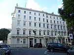
Lowndes Square is a residential garden square at the north-west end of Belgravia, London, SW1. It is formed of archetypal grand terraces of light stucco houses, cream or white. The length of the central rectangular garden is parallel with Sloane Street to the west; visible from the north-west corner is a corner of the Harvey Nichols store, beyond which is Knightsbridge tube station. Ecclesiastically (that is, in the Anglican church), it remains in a northern projection of one of the parishes of Chelsea, save its east side, in the very small parish of St Paul, Knightsbridge, a division which is mirrored secularly by the boundaries of two London Boroughs (Westminster and Kensington and Chelsea).
Excerpt from the Wikipedia article Lowndes Square (License: CC BY-SA 3.0, Authors, Images).Lowndes Square
Harriet Street, London Brompton (Royal Borough of Kensington and Chelsea)
Geographical coordinates (GPS) Address Nearby Places Show on map
Geographical coordinates (GPS)
| Latitude | Longitude |
|---|---|
| N 51.500277777778 ° | E -0.15861111111111 ° |
Address
Lownes Square Gardens
Harriet Street
SW1X 9JL London, Brompton (Royal Borough of Kensington and Chelsea)
England, United Kingdom
Open on Google Maps


