place

Little Weighton

OpenDomesdayUse British English from December 2014Villages in the East Riding of Yorkshire
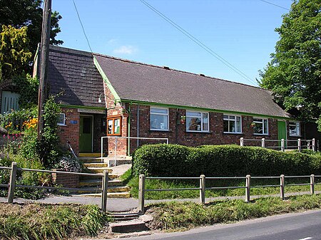
Village Hall Little Weighton

Little Weighton is a village in the East Riding of Yorkshire, England. It is approximately 5 miles (8 km) south-west of Beverley and 4.1 miles (6.6 km) west of Cottingham and forms part of the civil parish of Rowley.

Excerpt from the Wikipedia article Little Weighton (License: CC BY-SA 3.0, Authors, Images).

Little Weighton
Old Village Road,

Geographical coordinates (GPS) Address Nearby Places
placeShow on map

Wikipedia: Little WeightonContinue reading on Wikipedia

Geographical coordinates (GPS)

Latitude Longitude
N 53.79101 ° E -0.505287 °
placeShow on map

Address

Little Weighton Village Hall

Old Village Road
HU20 3US
England, United Kingdom
mapOpen on Google Maps

Village Hall Little Weighton
Share experience

Nearby Places

Humberside
Humberside

Humberside () was a non-metropolitan and ceremonial county in Northern England from 1 April 1974 until 1 April 1996. It was composed of land from either side of the Humber Estuary, created from portions of the East Riding of Yorkshire, West Riding of Yorkshire, and the northern part of Lindsey, Lincolnshire. The county council's headquarters was County Hall at Beverley, inherited from East Riding County Council. Its largest settlement and only city was Kingston upon Hull. Other notable towns included Goole, Beverley, Scunthorpe, Grimsby, Cleethorpes and Bridlington. The county stretched from Wold Newton in its northern tip to a different Wold Newton at its most southern point. Humberside bordered North Yorkshire to the north and west, South Yorkshire and Nottinghamshire to the south-west, and Lincolnshire to the south. It faced east towards the North Sea. Humberside was abolished on 1 April 1996, with four unitary authorities being formed: North Lincolnshire, North East Lincolnshire, Kingston upon Hull, and East Riding of Yorkshire. The name has continued in use as a geographical term, mainly in the media, and in the names of institutions such as Humberside Police and Humberside Fire and Rescue Service. These institutions did not change their names mainly due to costs. There were proposals to merge the police force with other Yorkshire forces and then change all the forces' names accordingly. However, these proposals were later ruled out.Humber Enterprise Zone was launched in 2012 to encourage industrial development at 16 sites around the estuary.

Walkington
Walkington

Walkington is a village and civil parish in the East Riding of Yorkshire, England. It is situated approximately 3 miles (4.8 km) to the south-west of the town of Beverley on the B1230 road, and Beverley Grammar School. The civil parish is formed by the village of Walkington and the hamlet of Broadgate. According to the 2011 UK census, Walkington parish had a population of 2,337, a reduction on the 2001 UK census figure of 2,481.To the east of the village is Broadgate, the site of a former mental hospital, named Broadgate Hospital.Another part of the former Broadgate Farm estate has been developed into a complex of holiday cottages named Broadgate Farm Cottages. The village has three public houses located along the main road, East End, the Barrel, the Ferguson Fawsitt Arms, and the Dog and Duck. Ferguson closed its doors on 4 October 2020 due to the coronavirus pandemic, although it reopened under new owners in early 2022. In the centre of Walkington is the village pond. The village school, Walkington Primary School is situated in Crake Wells, a minor street in the East End of the village. Before the year 1999 the school was divided between two sites which included the original school house at Northgate which dates back to the late 19th century. Before this, the street was called "School Lane". However, after a costly extension to the Crake Wells building, the infant and junior sections were joined together in 1999. The new building was officially opened by then Education Secretary David Blunkett, in October that year.The parish church of All Hallows is a Grade II* listed building. A Methodist church is situated next to West End.
Drewton Tunnel
Drewton Tunnel

Drewton Tunnel is a disused railway tunnel on the now closed Hull to Barnsley railway line - grid reference SE 952 335, western portal and SE 971 337, eastern portal. The tunnel is cut through chalk and the lining is a mix of bare chalk walls and brick. The first rail traffic used the tunnel in 1885. Drewton Tunnel is one of the longest disused tunnels in the United Kingdom at a length of 1 mile 354 yards (1.933 km), and lies to the east of the shorter Sugar Loaf Tunnel and Weedley Tunnel. The western portal of Drewton Tunnel is almost entirely buried with landfill and is situated in a chalk quarry operated by Stoneledge. This end of the tunnel has considerable deposits of mud on the former trackbed washed in by rainfall as a result of local quarrying operations. The eastern portal remains open although is protected with a security fence. The tunnel regularly experiences chalkfalls as the lining inside deteriorates in the damp conditions. The tunnel has five airshafts, the middle airshaft situated adjacent to Riplingham crossroads being the deepest. The area around this airshaft was used a temporary camp for navvies building the tunnel. Drewton Tunnel was closed to rail traffic in 1958. Since closure landfill has threatened the eastern approaches to the tunnel. The 83 foot deep Little Weighton Cutting has been completely filled in, as have other areas of open space around the eastern portal. Despite its continual decay Drewton Tunnel is now home to a large number of bats.