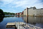
Great Bay National Estuarine Research Reserve

The Great Bay National Estuarine Research Reserve encompasses a diversity of land and water areas around Great Bay, an estuary in southeastern New Hampshire. Protected lands cover 10,235 acres (4,142 ha), including approximately 7,300 acres (3,000 ha) of open water and wetlands that include salt marshes, rocky shores, bluffs, woodlands, open fields, and riverine systems and tidal waters. Great Bay has a rich cultural history and was the first major commercial waterway developed by the early settlers. The National Estuarine Research Reserve System (NERRS) is a nationwide network of state-owned and -managed coastal protected areas. These are designated and supported by the National Oceanic and Atmospheric Administration (NOAA) under the United States Department of Commerce. The New Hampshire Fish and Game Department under the Marine Fisheries Division manages the Great Bay NERR. Designated in 1989, the reserve's primary purpose is to promote the wise use and management of the Great Bay estuary.
Excerpt from the Wikipedia article Great Bay National Estuarine Research Reserve (License: CC BY-SA 3.0, Authors, Images).Great Bay National Estuarine Research Reserve
Depot Road,
Geographical coordinates (GPS) Address Website Nearby Places Show on map
Geographical coordinates (GPS)
| Latitude | Longitude |
|---|---|
| N 43.05509 ° | E -70.89863 ° |
Address
Great Bay Discovery Center
Depot Road
03840
New Hampshire, United States
Open on Google Maps


