place

1979 Abbotsford landslip

1970s in Dunedin1979 disasters in New ZealandHistory of DunedinLandslides in 1979Landslides in New Zealand
Abbotsfield landslip

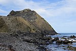
On 8 August 1979, a major landslip occurred in the Dunedin, New Zealand suburb of Abbotsford. It was the largest landslide in a built-up area in New Zealand's history, resulting in the destruction of 69 houses – around one sixth of the suburb – but no fatalities.

Excerpt from the Wikipedia article 1979 Abbotsford landslip (License: CC BY-SA 3.0, Authors, Images).

1979 Abbotsford landslip
Combat Zone Road, Dunedin Green Island

Geographical coordinates (GPS) Address Nearby Places
placeShow on map

Wikipedia: 1979 Abbotsford landslipContinue reading on Wikipedia

Geographical coordinates (GPS)

Latitude Longitude
N -45.897095 ° E 170.434739 °
placeShow on map

Address

Combat Zone Road

Combat Zone Road
9018 Dunedin, Green Island
Otago, New Zealand
mapOpen on Google Maps

Abbotsfield landslip
Share experience

Nearby Places

Anglican Diocese of Dunedin

The Diocese of Dunedin is one of the thirteen dioceses and hui amorangi (Māori bishoprics) of the Anglican Church in Aotearoa, New Zealand and Polynesia. The diocese covers the same area as the provinces of Otago and Southland in the South Island of New Zealand. Area 65,990 km2, population 272,541 (2001). Anglicans are traditionally the third largest religious group in Otago and Southland after Presbyterians and Roman Catholics. Description of arms: Gules between a cross saltire argent, four starts argent on the fess point a Bible. In 1814 the Gospel first preached in Aotearoa at Oihi, Northland by Anglican missionary Samuel Marsden, in 1841George Selwyn consecrated and appointed Bishop of New Zealand (including Polynesia and Melanesia). In 1843 the first Anglican missionaries to come to Southland and Otago were Tamihana Te Rauparaha and Matene Te Whiwhi. In 1852 Rev. John Fenton arrives in Dunedin; he was the first Anglican priest to settle south of Lyttleton. In 1856 when the Diocese of New Zealand was subdivided, Southland and Otago were included in the Diocese of Christchurch. In 1866 Henry Lascelles Jenner selected and ordained by the Archbishop of Canterbury “into the office of a Bishop of the United Church of England and Ireland in the colony of New Zealand”, with the intention that he be Bishop of Dunedin. In 1869 the Diocese of Dunedin formed from the Diocese of Christchurch. The first meeting of Dunedin's synod rejected Jenner's claim to the See 1871 Samuel Nevill enthroned as 1st bishop of Dunedin. The Bishop of Dunedin's cathedra is at St. Paul's Cathedral, Dunedin. The diocese has a total of 33 parishes. The adaption of "Local Shared Ministry" has been a strategy by which local people are ordained to serve in a parish which cannot afford to support full-time professional clergy. The diocese includes Anglo-Catholic, broad and Evangelical parishes.

Blackhead (New Zealand)

Blackhead is a promontory on the coast of Otago, New Zealand. It lies within the city limits of Dunedin, some 10 kilometres (6.2 mi) southwest of the city centre. The promontory extends some 500 metres into the ocean, and rises to a height of a little over 100 metres (330 ft). Māori names for Blackhead include Te Wai o Tinarau (the waters of Tinarau) and Makereatu (to leave a seed).The area of coast to the east of Blackhead is rugged and steep, with many cliff prominences. The tourist attraction of Tunnel Beach lies in this area, 3 km from Blackhead. To the west, the coast is more low-lying with beaches. The community of Waldronville is located here, some 1500 metres from Blackhead, close to the mouth of the Kaikorai Stream. A beach under the shadow of the quarry, Blackhead Beach, is a popular local surfing spot.Geologically, Blackhead formed around a peripheral vent of the Dunedin Volcano about 10 mya, the eroded and long-extinct remains of which form the ridge of hills surrounding Otago Harbour. Notable features of Blackhead relating to its origins include basalt columns, similar to those located at Second Beach, several kilometres to the east. Some of these are readily viewed by the public, such as the series of columns at the western end, which are accessible from Waldronville and Blackhead Beaches. Many of the more spectacular formations, such as the "Roman Baths" and "The Docks" are much harder and more hazardous to access, as they lie on the seaward side of the outcrop. Another feature which is equally difficult to access is Caversham Cavern, one of the largest sea caves on the Otago coast.

Calton Hill, New Zealand

Calton Hill is an elevated southern residential suburb of the City of Dunedin in New Zealand's South Island. The suburb is named after Calton Hill in Edinburgh, Scotland, and some of its street names carry similar etymological roots. The suburb was established in the 1900s, as part of the second wave of suburban development in Dunedin. The parent suburb is Caversham, one of Dunedin's (and New Zealand's) oldest suburbs, established two generations prior as part of the first wave of settlement of the area. During the first wave of settlement before Calton Hill was established, it is unclear what modern day Calton Hill was called; possibilities include Caversham Hills or, more informally, John Sidey's farm. Calton Hill is the geographical area bounded by the Dunedin Southern Motorway to the north and the Caversham Valley Forest Reserve beyond; farmland in the south and west that borders Concord and the Burnside industrial area; and an arbitrary eastern border of Corstorphine Road, Sidey Street, Cole Street and South Road (where it terminates near the Dunedin Southern Motorway). The South Island Main Trunk railway and the motorway (part of State Highway 1) further distinguish its northern border. For many of those on the northern and eastern slopes, Calton Hill has views to Mt Cargill (Kapukataumahaka) and Flagstaff (Te Whanaupaki) in the north and the Pacific Ocean in the south-east. To the east, Calton Hill looks over the central plains of Dunedin city with Signal Hill (Te Pahuri o te Rangipohika), the Otago Harbour and Otago Peninsula in the distance. For those on the western slopes, the Kaikorai Valley and Green Island are in immediate view with Saddle Hill and the Taieri Plains beyond.