place

Tunnel Beach

Beaches of OtagoNatural archesRock formations of OtagoTourist attractions in Otago
Tunnel Beach New Zealand I

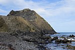
Tunnel Beach is a locality 7.5 kilometres (4.7 mi) southwest of the city centre of Dunedin, New Zealand. Located just south of St Clair, Tunnel Beach has sea-carved sandstone cliffs, rock arches and caves. Beyond the beauty of the rugged sandstone cliffs, its claim to fame is the tunnel down to the beach that a local politician, John Cargill, son of Captain William Cargill, had commissioned for his family in the 1870s. Local legend says that one or more of Cargill's daughters drowned while swimming at the beach, but there is no truth to this story.The tunnel itself is rough-hewn, and still shows the marks of the hand working which created it. Originally a simple slope, concrete steps were added when it was opened to the public in 1983. Access to the beach is via the DOC Reserve, and is open year round. The track is a popular walking excursion. It descends from 150 metres (490 ft) above sea level at its start, a short distance off Blackhead Road, winding for some 1200 metres to the top of the tunnel close to a natural sea arch. The tunnel descends 72 steps to the beach, and is dimly naturally lit. Note that the path down is steep and can be very slippery following wet weather.

Excerpt from the Wikipedia article Tunnel Beach (License: CC BY-SA 3.0, Authors, Images).

Tunnel Beach
Tunnel Beach Track, Dunedin Corstorphine

Geographical coordinates (GPS) Address Nearby Places
placeShow on map

Wikipedia: Tunnel BeachContinue reading on Wikipedia

Geographical coordinates (GPS)

Latitude Longitude
N -45.921229 ° E 170.458556 °
placeShow on map

Address

Tunnel Beach Track

Tunnel Beach Track
9012 Dunedin, Corstorphine
Otago, New Zealand
mapOpen on Google Maps

Tunnel Beach New Zealand I
Share experience

Nearby Places

Cargill's Castle
Cargill's Castle

The ruins of Cargill's Castle stand on a promontory overlooking the Pacific Ocean in New Zealand's southern city of Dunedin. It is one of about ten castles in New Zealand, the other one in Otago being nearby Larnach Castle. More a castle in name than in fact, this Italianate mansion was built for Edward Cargill, eighth child of city founder William Cargill, in the late 19th century, who called it The Cliffs. Designed by the young architect Francis Petre, and built in concrete by Harry Lyders at a cost of £14,000, it was completed in 1877. Several kilometres south of the castle is Tunnel Beach, so named because this quiet beach is only accessible through a steeply sloping tunnel cut into the 60 metres (200 ft) high cliffs by the Cargill family. It is also very likely that Petre was the supervisor of the construction of the tunnel. While designing the house, Petre fell in love with Cargill's daughter Margaret. After a difficult courtship (due to Petre's staunch Catholicism and the Cargill family's equally staunch Presbyterianism) the couple were eventually permitted to marry, the wedding taking place in the villa's principal salon on 1 March 1881.The building was gutted by a fire in 1892, Cargill restored the castle but was unable to meet the cost of replacing all the wooden furnishings, though he did add a ballroom. The castle had several owners after Cargill's death in 1903, and was opened as a restaurant and cabaret in the 1930s by John Hutton, which became popular with visiting servicemen during World War II. Plans have been made on several occasions to restore the building to its former glory, but none have yet borne fruit. The castle now lies in ruins, a shell of what it once was. There is no public access to the site. Several kilometres south of the castle is Tunnel Beach, so named because this quiet beach is only accessible through a steeply sloping tunnel cut into the 60-metre high cliffs by the Cargill family. The beach is reached via a public walking track, some six kilometres southwest of the city centre.

Calton Hill, New Zealand

Calton Hill is an elevated southern residential suburb of the City of Dunedin in New Zealand's South Island. The suburb is named after Calton Hill in Edinburgh, Scotland, and some of its street names carry similar etymological roots. The suburb was established in the 1900s, as part of the second wave of suburban development in Dunedin. The parent suburb is Caversham, one of Dunedin's (and New Zealand's) oldest suburbs, established two generations prior as part of the first wave of settlement of the area. During the first wave of settlement before Calton Hill was established, it is unclear what modern day Calton Hill was called; possibilities include Caversham Hills or, more informally, John Sidey's farm. Calton Hill is the geographical area bounded by the Dunedin Southern Motorway to the north and the Caversham Valley Forest Reserve beyond; farmland in the south and west that borders Concord and the Burnside industrial area; and an arbitrary eastern border of Corstorphine Road, Sidey Street, Cole Street and South Road (where it terminates near the Dunedin Southern Motorway). The South Island Main Trunk railway and the motorway (part of State Highway 1) further distinguish its northern border. For many of those on the northern and eastern slopes, Calton Hill has views to Mt Cargill (Kapukataumahaka) and Flagstaff (Te Whanaupaki) in the north and the Pacific Ocean in the south-east. To the east, Calton Hill looks over the central plains of Dunedin city with Signal Hill (Te Pahuri o te Rangipohika), the Otago Harbour and Otago Peninsula in the distance. For those on the western slopes, the Kaikorai Valley and Green Island are in immediate view with Saddle Hill and the Taieri Plains beyond.

Blackhead (New Zealand)

Blackhead is a promontory on the coast of Otago, New Zealand. It lies within the city limits of Dunedin, some 10 kilometres (6.2 mi) southwest of the city centre. The promontory extends some 500 metres into the ocean, and rises to a height of a little over 100 metres (330 ft). Māori names for Blackhead include Te Wai o Tinarau (the waters of Tinarau) and Makereatu (to leave a seed).The area of coast to the east of Blackhead is rugged and steep, with many cliff prominences. The tourist attraction of Tunnel Beach lies in this area, 3 km from Blackhead. To the west, the coast is more low-lying with beaches. The community of Waldronville is located here, some 1500 metres from Blackhead, close to the mouth of the Kaikorai Stream. A beach under the shadow of the quarry, Blackhead Beach, is a popular local surfing spot.Geologically, Blackhead formed around a peripheral vent of the Dunedin Volcano about 10 mya, the eroded and long-extinct remains of which form the ridge of hills surrounding Otago Harbour. Notable features of Blackhead relating to its origins include basalt columns, similar to those located at Second Beach, several kilometres to the east. Some of these are readily viewed by the public, such as the series of columns at the western end, which are accessible from Waldronville and Blackhead Beaches. Many of the more spectacular formations, such as the "Roman Baths" and "The Docks" are much harder and more hazardous to access, as they lie on the seaward side of the outcrop. Another feature which is equally difficult to access is Caversham Cavern, one of the largest sea caves on the Otago coast.

Caversham, New Zealand

Caversham is one of the older suburbs of the city of Dunedin, in New Zealand's South Island. It is sited at the western edge of the city's central plain at the mouth of the steep Caversham Valley, which rises to the saddle of Lookout Point. Major road and rail routes south lie nearby; the South Island Main Trunk railway runs through the suburb, and a bypass skirts its main retail area, connecting Dunedin's one-way street system with the Dunedin Southern Motorway. The suburb is linked by several bus routes to its neighbouring suburbs and central Dunedin. The suburb was founded by wealthy pioneer William Henry Valpy, and its name reflects his family connections with the town of Reading, in the English county of Berkshire. Caversham grew rapidly during the Central Otago Gold Rush of the 1860s because of its location on routes south to the Otago hinterland. By the end of the 19th century, Caversham was heavily industrialised, and its population included many skilled or semi-skilled tradespeople. This, combined with the community's strong Protestant roots, led to the area's generally left-leaning political stance. Caversham's early history has been the subject of the Caversham Project, a major historical and archaeological study by the University of Otago. Caversham was a separate borough until 1904, when it was amalgamated with Dunedin city. At a national level, it is part of the Taieri electorate. Caversham is now predominantly residential, with some industrial premises in the east (notably the Hillside Railway Workshops) and a retail district centred on South Road and Hillside Road. Residents are generally of low socio-economic status. Caversham's notable buildings include the heritage listed Lisburn House and several prominent church buildings. Another landmark is the suburb's war memorial, which is the main gate of Caversham School, the suburb's primary school. Caversham also contains a special-needs school. The nearest secondary schools operate in St Clair, 1 kilometre (0.62 mi) to the south. Caversham has strong sporting connections, and is the location of Carisbrook, until recently one of Dunedin's main sports venues. The suburb is home to the Southern Rugby Football Club, and gives its name to Caversham Football Club. Several notable sportspeople have associations with Caversham, among them Test cricketer Clarrie Grimmett and father and son rugby union administrators "Old Vic" and "Young Vic" Cavanagh. Other notable people with Caversham connections include politician Thomas Kay Sidey, architect Edmund Anscombe, and surveyor John Turnbull Thomson.

Anglican Diocese of Dunedin

The Diocese of Dunedin is one of the thirteen dioceses and hui amorangi (Māori bishoprics) of the Anglican Church in Aotearoa, New Zealand and Polynesia. The diocese covers the same area as the provinces of Otago and Southland in the South Island of New Zealand. Area 65,990 km2, population 272,541 (2001). Anglicans are traditionally the third largest religious group in Otago and Southland after Presbyterians and Roman Catholics. Description of arms: Gules between a cross saltire argent, four starts argent on the fess point a Bible. In 1814 the Gospel first preached in Aotearoa at Oihi, Northland by Anglican missionary Samuel Marsden, in 1841George Selwyn consecrated and appointed Bishop of New Zealand (including Polynesia and Melanesia). In 1843 the first Anglican missionaries to come to Southland and Otago were Tamihana Te Rauparaha and Matene Te Whiwhi. In 1852 Rev. John Fenton arrives in Dunedin; he was the first Anglican priest to settle south of Lyttleton. In 1856 when the Diocese of New Zealand was subdivided, Southland and Otago were included in the Diocese of Christchurch. In 1866 Henry Lascelles Jenner selected and ordained by the Archbishop of Canterbury “into the office of a Bishop of the United Church of England and Ireland in the colony of New Zealand”, with the intention that he be Bishop of Dunedin. In 1869 the Diocese of Dunedin formed from the Diocese of Christchurch. The first meeting of Dunedin's synod rejected Jenner's claim to the See 1871 Samuel Nevill enthroned as 1st bishop of Dunedin. The Bishop of Dunedin's cathedra is at St. Paul's Cathedral, Dunedin. The diocese has a total of 33 parishes. The adaption of "Local Shared Ministry" has been a strategy by which local people are ordained to serve in a parish which cannot afford to support full-time professional clergy. The diocese includes Anglo-Catholic, broad and Evangelical parishes.