place

Irondequoit Creek

Rivers of Monroe County, New YorkRivers of New York (state)Rivers of Ontario County, New York
Irondequoit Creek in Ellison Park

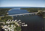
Irondequoit Creek is a stream in eastern Monroe County, New York that feeds Irondequoit Bay. It begins in rural West Bloomfield in Ontario County, flowing north into the town of Mendon in Monroe County. Accumulating a few small tributaries, it twists eastward back into the Ontario County town of Victor, then back north into Monroe County, where it flows through the towns of Perinton and Penfield on its way to the bay. It also skirts the edge of the combined town and village of East Rochester. The creek is believed to lie in a valley carved out by a pre-glacial Genesee River, which at the time would have flowed into Lake Ontario where Irondequoit Bay does today. Glacial debris caused the river to be rerouted as the glaciers retreated, leaving only the comparatively small creek (Rogers 1893). The first settlements in the town of Penfield sprang up along the creek, as its waters were well suited to mills. The Daisy Flour Mill, previously a restaurant, was the last of over a dozen mills that once used the creek's waters. The creek's valley caused a problem for the engineers of the original Erie Canal, who ultimately had to build the Great Embankment aqueduct to bridge the valley near Bushnell's Basin (Fairchild 1896:134, Farley 2010, Schoff:505). The creek is stocked annually with fish by the New York State Department of Environmental Conservation for year-round fishing.

Excerpt from the Wikipedia article Irondequoit Creek (License: CC BY-SA 3.0, Authors, Images).

Irondequoit Creek
Empire Boulevard,

Geographical coordinates (GPS) Address Nearby Places
placeShow on map

Wikipedia: Irondequoit CreekContinue reading on Wikipedia

Geographical coordinates (GPS)

Latitude Longitude
N 43.1775 ° E -77.525555555556 °
placeShow on map

Address

Empire Boulevard 1086
14609
New York, United States
mapOpen on Google Maps

Irondequoit Creek in Ellison Park
Share experience

Nearby Places

Irondequoit Bay
Irondequoit Bay

Irondequoit Bay is a large body of water located in northeastern Monroe County, New York. The bay, roughly 0.5 miles (0.80 km) wide and 4 miles (6.4 km) in length, is fed by Irondequoit Creek to the south and flows into Lake Ontario at its northern end. On average, the surface of Irondequoit Bay rests at 245 feet (75 m) above sea level and is 80 feet (24 m) deep at its deepest point a short distance north of the Irondequoit Bay Bridge carrying the six-lane New York State Route 104 over the bay.The center of the bay acts as the eastern border for the town of Irondequoit and the western border of the towns of Penfield and Webster. The Irondequoit–Penfield boundary continues along the center of Irondequoit Creek south of the New York State Route 404 float bridge.During the past million years there were four glacial ages that covered the Rochester area with ice and impacted the geography of the area. The most recent glacier that left evidence here was about 100,000 years ago and it caused compression of the earth by as much as 2,500 feet (760 m). About 12,000 years ago, the area underwent massive changes, which included the rerouting of the Genesee River and other water bodies. Since the earth rebounded from the melting glaciers more rapidly in Canada than in New York, water from Lake Ontario was spilled over New York due to its lower elevation. During this time, the original outlet of the Genesee River was flooded out, creating Irondequoit Bay.On a French map of the area from 1688 titled "Le Lac Ontario" Irondequoit Bay was referred to as the "swamp of the Senecas". Prior to the 1840s, the bay was known as "Teoronto Bay."Seven parks abut the bay: Devil's Cove Park, Webster Ellison Park, Penfield Irondequoit Bay Marine Park, Irondequoit Abraham Lincoln Park (formerly Irondequoit Bay Park East), Penfield Irondequoit Bay Park West, Irondequoit LaSalle's Landing Park, Penfield Sandbar Park, Webster