place

Irondequoit Bay

Bays of Lake OntarioBays of New York (state)Bodies of water of Monroe County, New York
IrondequoitBayViewedFromLucienMorinPark

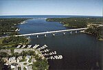
Irondequoit Bay is a large body of water located in northeastern Monroe County, New York. The bay, roughly 0.5 miles (0.80 km) wide and 4 miles (6.4 km) in length, is fed by Irondequoit Creek to the south and flows into Lake Ontario at its northern end. On average, the surface of Irondequoit Bay rests at 245 feet (75 m) above sea level and is 80 feet (24 m) deep at its deepest point a short distance north of the Irondequoit Bay Bridge carrying the six-lane New York State Route 104 over the bay.The center of the bay acts as the eastern border for the town of Irondequoit and the western border of the towns of Penfield and Webster. The Irondequoit–Penfield boundary continues along the center of Irondequoit Creek south of the New York State Route 404 float bridge.During the past million years there were four glacial ages that covered the Rochester area with ice and impacted the geography of the area. The most recent glacier that left evidence here was about 100,000 years ago and it caused compression of the earth by as much as 2,500 feet (760 m). About 12,000 years ago, the area underwent massive changes, which included the rerouting of the Genesee River and other water bodies. Since the earth rebounded from the melting glaciers more rapidly in Canada than in New York, water from Lake Ontario was spilled over New York due to its lower elevation. During this time, the original outlet of the Genesee River was flooded out, creating Irondequoit Bay.On a French map of the area from 1688 titled "Le Lac Ontario" Irondequoit Bay was referred to as the "swamp of the Senecas". Prior to the 1840s, the bay was known as "Teoronto Bay."Seven parks abut the bay: Devil's Cove Park, Webster Ellison Park, Penfield Irondequoit Bay Marine Park, Irondequoit Abraham Lincoln Park (formerly Irondequoit Bay Park East), Penfield Irondequoit Bay Park West, Irondequoit LaSalle's Landing Park, Penfield Sandbar Park, Webster

Excerpt from the Wikipedia article Irondequoit Bay (License: CC BY-SA 3.0, Authors, Images).

Irondequoit Bay
Bay Shore Boulevard, City of Rochester

Geographical coordinates (GPS) Address Nearby Places
placeShow on map

Wikipedia: Irondequoit BayContinue reading on Wikipedia

Geographical coordinates (GPS)

Latitude Longitude
N 43.205 ° E -77.531 °
placeShow on map

Address

Bay Shore Boulevard 1500
14622 City of Rochester
New York, United States
mapOpen on Google Maps

IrondequoitBayViewedFromLucienMorinPark
Share experience

Nearby Places

Irondequoit Bay Outlet Bridge

The Irondequoit Bay Outlet Bridge is a bobtail swing truss bridge in the northeastern suburbs of Rochester, New York, in the United States. It spans the outlet of Irondequoit Bay at Lake Ontario, carrying vehicular traffic between Culver Road in Irondequoit and Lake Road in Webster. The bridge is closed to vehicular traffic (bridge in open position) during the boating season from April to November, allowing marine traffic to travel between Lake Ontario and Irondequoit Bay. During the boating season, the bridge is a popular spot for visitors to watch the boat traffic, walk out onto the nearby jetties, and fish. The swing bridge replaced a two-lane fixed timber bridge that existed from 1929 to 1985. The old bridge's removal was part of an U.S. Army Corps of Engineers project to open up the Irondequoit Bay to boating.According to Monroe County, the concrete and steel bridge is 185.5 ft long (56.5 m) with two spans and a 24-foot (7.3 m) roadway; it was completed in 1998 for $4.8 million (including renovation of nearby Irondequoit Bay Marine Park). The bridge has a main span of 132.5 feet (40.4 m) on its eastern end with a counter-weighted 53-foot (16 m) span on its western end. To open or close the bridge requires about two hours of setup time, 30 minutes turning time and 2 hours of set-down time. The bridge weighs approximately 425 tons.On the west side of the bridge there is a small public beach area, restrooms, and a jetty which protrudes out into the lake and terminates with a small lighthouse. A shorter jetty on the east side provides views of the lake and channel to the Webster visitors. Seabreeze Amusement Park is about 0.5 miles (0.80 km) southwest and visible from the overlooks. The bridge may be used as an alternate route for the Seaway Trail when the bridge is open to traffic during the winter months. Each year, the bridge is swung to the in-storage position (open to boaters) on April 1, after 9:00 am, and to the in-use position (open to vehicular traffic) on November 1. If April 1st happens to fall on a weekend day, then the bridge will be placed into storage on the Monday following the weekend. If November 1st happens to fall on a weekend day then the bridge will be put in-use on the Monday after the weekend. A feasibility study has been conducted to explore options to provide year-round access across the Bay Outlet. A series of public meetings was held, including one on January 11, 2018, at Irondequoit Town Hall where highlights and findings from the draft report were shared. http://www.irondequoit.org/community/irondequoit-bay-outlet-bridge-feasibility-study Per https://www.democratandchronicle.com/story/news/2018/01/12/irondequoit-bay-outlet-bridge-options/1026565001/ the highest scoring options involved changing the existing bridge.