place

Ridgmont

Bedfordshire geography stubsCentral Bedfordshire DistrictCivil parishes in BedfordshireUse British English from July 2016Villages in Bedfordshire
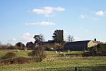
Water Tower and Church, Ridgmont geograph.org.uk 422745

Ridgmont is a small village and civil parish in Bedfordshire, England. It is located beside junction 13 of the M1 motorway, and close to Milton Keynes and Woburn Abbey. The 2001 census states the total population to be 418, reducing to 411 at the 2011 Census.The parish is first mentioned in the Domesday book of 1086, by its original name of Segenhoe, which was approximately 500 yards (metres) south east from where the village now lies. In 1227 the name Rugemund was first recorded, taken from the French 'rouge mont' which means red hill.The modern village lies on top of a greensand ridge at approximately 350 feet (110 m) above sea level. The surrounding valley has underlying 'Upper Jurassic Oxford Clay' which is suitable for making bricks. In 1935 the Ridgmont Brickworks were built by the Ridgmont Fletton Brick Company. By 1979, as part of the London Brick Company, the works had 25 chimneys and was said to be the second-largest brickworks in the world.The large Amazon.co.uk warehouse now occupies the site of the former brickworks, which is situated beside the Ridgmont railway station. November 2006 saw work start on the Ridgmont Bypass, and the £15.5 million project was finished in June 2008. The A507 Ridgmont relief road is designed to carry 80 per cent of heavy traffic away from the neighbouring villages.

Excerpt from the Wikipedia article Ridgmont (License: CC BY-SA 3.0, Authors, Images).

Ridgmont
Church Street,

Geographical coordinates (GPS) Address Nearby Places
placeShow on map

Wikipedia: RidgmontContinue reading on Wikipedia

Geographical coordinates (GPS)

Latitude Longitude
N 52.01506 ° E -0.57838 °
placeShow on map

Address

Church Street

Church Street
MK43 0UA
England, United Kingdom
mapOpen on Google Maps

Water Tower and Church, Ridgmont geograph.org.uk 422745
Share experience

Nearby Places

Lidlington
Lidlington

Lidlington is a small village and civil parish in Central Bedfordshire, England surrounded by farmland, in the Marston Vale. The hamlets of Boughton End and Thrupp End are also part of the parish. The village has an unusual Gothic-style church built by the Duke of Bedford in 1845 and a thatched pub on its High Street. Lidlington is set on the Southern part of the vale's 'basin'. The village has a lower school for 5–9 year olds named after Thomas Johnson, a Dick Whittington-type character who was Lord Mayor of London in 1840–41. Brogborough Lake (also known as Lidlington Lake) at the edge of the village is popular for birdwatching and fishing. The lake is also used for windsurfing and stand up paddle surfing. The nearby landfill site (which was known as Brogborough Landfill site) was the largest landfill in Europe before closing to new deposits in 2009. With a population of about 1300 voters and over 500 homes, Lidlington is defined as a small village. It has a village hall, a pub, a hairdresser and a general store, plus a "farm store" on the A421. Lidlington has retained a daily doorstop milk and newspaper delivery service, but has lost its village post office. The village also has a single congregation Anglican/Baptist/Methodist church, members of which worship regularly in the chapel. The village lies between the main A421 Bedford to Milton Keynes road and the A507 Ampthill to Woburn road. Lidlington railway station is on the Marston Vale Line which gives good access for walkers along the Greensand Ridge long-distance footpath which passes nearby the village. Local speculation is that the ridge was the model for the "Delectable Mountains" in John Bunyan's Pilgrim's Progress. Lidlington Hill may also be Bunyan's "Hill of Difficulty". Lidlington is adjacent to the site of the Millbrook Proving Ground (formerly the Vauxhall test track), which is distinguishable from the air by its large circular track. To the north of the Parish of Lidlington is Cranfield Airport, used by small aircraft and for training flights. To the west of the village at the former brick works is a business park which is home to Amazon.com UK. The former brickworks to the east of the village are known as Lidlington Pit and forms part of the regeneration of the Forest of Marston Vale area. Like many other villages in the area it was formerly part of the Duke of Bedford's estate. Hence some London place names e.g. Bedford Square, Russell Square, Eversholt Street, Woburn Place and in Camden, NW1, Lidlington Place can be found near Mornington Crescent underground station.Lidlington United currently play in the Bedfordshire Football League Premier Division after being promoted in three successive seasons. The village also has a cricket team, and all-weather tennis courts at the recreation ground. Lidlington is mentioned in the Domesday Book. The entry reads Litinclitone: Abbess of Barking. In April 2008 the area was listed as a site for the Government's 'ECO-town' competition. In July 2008 the brownfield locations for the 'ECO-town' were dropped in favour of using the prime farmland surrounding Lidlington. Early in 2009 the developers' plans for an 'ECO-town' were dropped.