Navas del Rey
Madrid geography stubsMunicipalities in the Community of Madrid

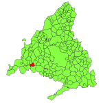
Navas del Rey is a municipality of the Community of Madrid, Spain. It is located 52 kilometers from the city of Madrid, which is accessed by the road M-501 . Navas del Rey is located in a transition zone between the Sierra de Guadarrama and Sierra de Gredos . To the north the municipality borders the village of Robledo de Chavela, east to the towns of Chapinería and Colmenar del Arroyo, south to Aldea del Fresno and west Pelayos Dam and San Martin de Valdeiglesias . Along with other municipalities make up what is called the Commonwealth of Pinares, through which are channeled much of the initiatives from the various municipalities that are grouped in this commonwealth .
Excerpt from the Wikipedia article Navas del Rey (License: CC BY-SA 3.0, Authors, Images).Navas del Rey
Camino del Santo,
Geographical coordinates (GPS) Address Nearby Places Show on map
Geographical coordinates (GPS)
| Latitude | Longitude |
|---|---|
| N 40.383333333333 ° | E -4.25 ° |
Address
Camino del Santo
Camino del Santo
28695
Community of Madrid, Spain
Open on Google Maps


