place

Wrangle, Lincolnshire

Borough of BostonCivil parishes in LincolnshireUse British English from November 2013Villages in Lincolnshire
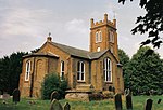
The Church of St Mary and St Nicholas, Wrangle geograph.org.uk 589698

Wrangle is a village in the Boston Borough of Lincolnshire, England. It is situated approximately 9 miles (14 km) north-east from the town of Boston. The population of Wrangle civil parish in 2001 was 1,265, increasing to 1,397 at the 2011 census.Wrangle is one of eighteen parishes which, together with Boston, form the Borough of Boston. The local government has been arranged in this way since the reorganisation of 1 April 1974, which resulted from the Local Government Act 1972. This parish forms part of the Old Leake and Wrangle electoral ward.Hitherto, the parish had formed part of Boston Rural District, in the Parts of Holland. Holland was one of the three divisions (formally known as parts) of the traditional county of Lincolnshire. Since the Local Government Act of 1888, Holland had been in most respects, a county in itself.

Excerpt from the Wikipedia article Wrangle, Lincolnshire (License: CC BY-SA 3.0, Authors, Images).

Wrangle, Lincolnshire
Main Road,

Geographical coordinates (GPS) Address Nearby Places
placeShow on map

Wikipedia: Wrangle, LincolnshireContinue reading on Wikipedia

Geographical coordinates (GPS)

Latitude Longitude
N 53.038736 ° E 0.126474 °
placeShow on map

Address

Main Road
PE22 9AH , Wrangle CP
England, United Kingdom
mapOpen on Google Maps

The Church of St Mary and St Nicholas, Wrangle geograph.org.uk 589698
Share experience

Nearby Places

Benington Sea End
Benington Sea End

Benington Sea End is a hamlet in the Benington civil parish of the Borough of Boston in Lincolnshire, England. It is 5 miles (8 km) east-northeast from Boston and 30 miles (48 km) south-east from the city and county town of Lincoln. Benington Sea End is less than 1 mile (1.6 km) south-east from parish village of Bennington and the A52 road, which locally runs from Boston to Skegness. It is centred on the junction between Churchway, Sea End Road, and Spicer's Lane, and includes Sea End Lane and the circuitous Lamb Lane at the south-east. The hamlet is 1 mile north-east from the north-east bank of The Wash. At the east of the hamlet is a sea defence bank, at the south-west of which rises the Delph drain which runs along the landward side. A Second World War pillbox, an Historic England listed monument, sits on the bank just south from where it is crossed by Sea Lane.The hamlet comprises cottages, four farms, and at the junction of Churchway and Spicer's Lane, The Old Rectory, which is a Grade II listed two-storey, hip roofed former rectory dating to 1830, described in the 1872 White's Directory as "a good residence, with pleasant grounds, near the sea coast". The rectory in the early 20th century was being rented out by the Church of England, and was later sold by them in 1924. The last rector of Benington to live there was Canon Walter Fallows Hodge (1878 - 1938).Trade directories recorded late 19th and early 20th century agricultural production as of chiefly wheat and potatoes, and by 1919, celery. In 1872 there were listed seven farmers, and two fishermen of the same family; by 1885, five farmers; by 1905 four farmers, two of whom were of the same family, and one also a bulb merchant; and by 1919, a cottage farmer, a smallholder, and five farmers, one of whom was also listed as a potato grower.

Benington, Lincolnshire

Benington is a village and civil parish in the Borough of Boston in Lincolnshire, England, and approximately 4 miles (6 km) east of Boston, and on the A52 road. The parish contains the hamlets of Benington Sea End and West End. Nearby villages are Butterwick and Leverton. Benington parish has a population of 569, increasing to 580 at the 2011 Census. It is one of eighteen parishes which, together with Boston, form the borough. Local government has been arranged in this way since the reorganisation of 1 April 1974, which resulted from the Local Government Act 1972. The parish forms part of the Coastal electoral ward. Hitherto, the parish had formed part of Boston Rural District, in the Parts of Holland. Holland was one of the three divisions (formally known as parts) of the traditional county of Lincolnshire. Since the Local Government Act of 1888, Holland had been in most respects, a county in itself. The name derives from Old English meaning "Bennas farm or settlement". The parish church is a Grade I listed building dedicated to All Saints and dating from the 13th to 15th centuries, although it was restored in 1873 by James Fowler of Louth. It has a 14th-century font. It closed as a church in 2003 (with its last service in 2001) and was boarded up. In 2015, the Benington Community Heritage Trust received a grant from the Heritage Lottery Fund, and as at early 2021 it is being refurbished for use as a community centre "The Beonna at All Saints" (named after Beonna, an eighth century king of East Anglia). Purril's Almshouses date from the 15th century, although rebuilt in 1728, and are Grade II listed.