Saint Marys River (Virginia)
Rivers of Augusta County, VirginiaRivers of VirginiaTributaries of the James RiverVirginia river stubs
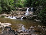
The Saint Marys River is an 8.4-mile-long (13.5 km) tributary of the South River in Augusta County in the U.S. state of Virginia. By the South and Maury rivers, it is part of the James River watershed. The river flows through the Blue Ridge Mountains, rising north of the Blue Ridge Parkway near the highlands known as Big Levels, and flows west to the South River near the village of Steeles Tavern.
Excerpt from the Wikipedia article Saint Marys River (Virginia) (License: CC BY-SA 3.0, Authors).Saint Marys River (Virginia)
Cold Springs Road,
Geographical coordinates (GPS) Address Website Nearby Places Show on map
Geographical coordinates (GPS)
| Latitude | Longitude |
|---|---|
| N 37.92875 ° | E -79.17475 ° |
Address
Shenandoah Stone
Cold Springs Road 5047
24472
Virginia, United States
Open on Google Maps


