Kaaterskill Clove
Canyons and gorges of New York (state)Hudson River School sitesLandforms of Greene County, New YorkTourist attractions in Greene County, New York

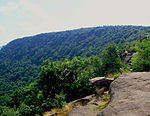
Kaaterskill Clove is a deep gorge, or valley, in New York's eastern Catskill Mountains, lying just west of the village of Palenville and in Haines Falls. The clove was formed by Kaaterskill Creek, a tributary of Catskill Creek rising west of North Mountain, and is estimated by geologists to be as much as 1 million years old. Kaaterskill High Peak and Roundtop Mountain rise to the south of the gorge, while South Mountain is to its north. This makes the gorge as deep as 2,500 feet in places.
Excerpt from the Wikipedia article Kaaterskill Clove (License: CC BY-SA 3.0, Authors, Images).Kaaterskill Clove
Malden Avenue,
Geographical coordinates (GPS) Address Nearby Places Show on map
Geographical coordinates (GPS)
| Latitude | Longitude |
|---|---|
| N 42.173978 ° | E -74.025413 ° |
Address
Malden Avenue 270
12463
New York, United States
Open on Google Maps


