Platte Clove
Catskill ParkHudson River School sitesLandforms of Greene County, New YorkLandforms of Ulster County, New YorkValleys of New York (state)

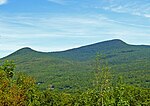
Platte Clove, sometimes Plattekill Clove, is a narrow and steep valley in the Catskill Mountains of New York. The valley is situated between Kaaterskill High Peak and Roundtop Mountain to the north and Plattekill Mountain and Indian Head Mountain to the south. It is mostly in Greene County, although the lowest, eastern portions are in Ulster County. The stream that runs below is called Plattekill Creek. A few hiking trails go through the Clove including Devil's Path and Huckleberry Point Trail. The area hosts bicycle racing events.
Excerpt from the Wikipedia article Platte Clove (License: CC BY-SA 3.0, Authors, Images).Platte Clove
Platte Clove Road,
Geographical coordinates (GPS) Address Nearby Places Show on map
Geographical coordinates (GPS)
| Latitude | Longitude |
|---|---|
| N 42.126 ° | E -74.074 ° |
Address
Platte Clove Road
Platte Clove Road
New York, United States
Open on Google Maps


