place

San Nicolas de Tolentino Parish Church (Quezon City)

Asian church stubsPhilippine building and structure stubsRoman Catholic church stubsRoman Catholic churches in Quezon City

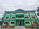
San Nicolas de Tolentino is a parish church in Quezon City. It belongs to the Roman Catholic Diocese of Cubao, under the Vicariate of Sto. Nino. It is under the care of the Augustinian Recollect Province of Saint Ezequiél Moreno. The parish was named after San Nicolas de Tolentino, the patron saint of the poor souls in purgatory, whose feast day is celebrated on 10 September. Recollect fathers expanded their apostolate by building a church, which later became the center of a sprawling parish extending from Visayas Avenue in the east, to Mindanao Avenue in the west, from Carmel II in the south to Tandang Sora in the north. Established on April 30, 1975, it was on May 11, 1975, that Fr. Alejandro Ramirez, OAR, was installed as the first parish priest, with Fr. Antonio Ausejo, OAR, and Fr. Clemente Jubera, OAR, as assistants. In response to the demand of the faithful, the parish was divided in two: Our Father Parish and Our Lady of Annunciation Parish were created within the San Nicholas de Tolentino territory. The Parish Priest is Father Delfin Castillo, OAR with estimated population of 10, 000 Catholics.

Excerpt from the Wikipedia article San Nicolas de Tolentino Parish Church (Quezon City) (License: CC BY-SA 3.0, Authors).

San Nicolas de Tolentino Parish Church (Quezon City)
Pluto Street, Quezon City

Geographical coordinates (GPS) Address External links Nearby Places
placeShow on map

Wikipedia: San Nicolas de Tolentino Parish Church (Quezon City)Continue reading on Wikipedia

Geographical coordinates (GPS)

Latitude Longitude
N 14.67226 ° E 121.03752 °
placeShow on map

Address

San Nicolas de Tolentino Parish Church

Pluto Street
1106 Quezon City (1st District)
Philippines
mapOpen on Google Maps

linkWikiData (Q7415012)
linkOpenStreetMap (252253662)

Share experience

Nearby Places

Mindanao Avenue
Mindanao Avenue

Mindanao Avenue (Filipino: Abenida Mindanao) is an eight-to-ten lane divided avenue connecting EDSA and NLEX and is a part of Circumferential Road 5 (C-5) in Metro Manila, Philippines. It is one of the three parallel roads that connects Tandang Sora and Congressional Avenues (Visayas Avenue and Luzon Avenue were the others); that is why it was named after the southernmost mainland of the Philippines, Mindanao. It used to be a 2-kilometer (1.2 mi) highway connecting North Avenue and Congressional Avenue, but as a part of the C-5 projects, Mindanao Avenue was extended to EDSA in the south and to Quirino Highway to the north. The new roads opened in 2000.Another road also named Mindanao Avenue, also in Quezon City, starts in Barangay Santa Monica, crosses Commonwealth Avenue and Regalado Highway, and terminates at a dead end at School of Saint Anthony in Barangay Greater Lagro, Quezon City. That road is not in any way connected to the original Mindanao Avenue but was planned to be the one and the same road according to the 1949 Master Plan for Quezon City. It would have connected the Diliman Quadrangle to the La Mesa Watershed area.Mindanao Avenue replaced some segments of Tandang Sora Avenue belonging to C-5; Tandang Sora has no access to North Luzon Expressway. NLEX Segment 8.1, also known as the NLEX Mindanao Avenue Link, began construction afterwards. In 2017, DPWH has resumed construction of the 3.2-kilometer (2.0 mi) Mindanao Avenue Extension Project, after being halted for years due to road right-of-way issues, notably involving residential areas. A total of 1.4-kilometer (0.87 mi) portion of the road was earlier completed and opened since 2014. In June 2018, DPWH has opened additional 700-meter (2,300 ft) portion from P. Dela Cruz Street to the current end at MGM Road. The road will be extended further until it meets General Luis Street in North Caloocan.

Tandang Sora Avenue
Tandang Sora Avenue

Tandang Sora Avenue, formerly known as Banlat Road, is a major east-west thoroughfare bisecting Quezon City in Metro Manila, the Philippines. It is a two-to-six lane highway and municipal road that runs for 9.6 kilometers (6.0 mi) from its eastern terminus at Magsaysay Avenue in Pansol and U.P. Campus in Diliman to its western terminus at Quirino Highway in Baesa and Talipapa in Novaliches, crossing Barangays Culiat, New Era, Pasong Tamo, Tandang Sora, and Sangandaan. The avenue's segment east of Commonwealth Avenue is a national secondary road with the route designation N129; it also forms part of the Circumferential Road 5 (C-5) network of the Metro Manila arterial road system. Its western segment in Tandang Sora and Culiat west of Commonwealth Avenue is a narrow municipal road classified as a national tertiary road. Tandang Sora Avenue was named after its location in the barangay of Tandang Sora. The barrio, in turn, was renamed from Talipapa in 1952 in honor of Filipina patriot Melchora Aquino.A flyover linking Tandang Sora Avenue with Luzon Avenue over Commonwealth Avenue in Culiat was built in 2009 as part of the C-5 Road network project. In February 2019, the Department of Public Works and Highways announced the demolition of a flyover of Commonwealth Avenue at the Tandang Sora junction in New Era to make way for the construction of the Tandang Sora station of the Manila Metro Rail Transit System Line 7 (MRT-7). A Metro Manila Subway station is also planned at the avenue's junction with Mindanao Avenue in Tandang Sora.