Pill Hill Historic District
Brookline, MassachusettsHistoric districts in Norfolk County, MassachusettsHistoric districts on the National Register of Historic Places in MassachusettsNRHP infobox with nocatNational Register of Historic Places in Brookline, Massachusetts ... and 3 more
Norfolk County, Massachusetts Registered Historic Place stubsQueen Anne architecture in MassachusettsUse mdy dates from August 2023

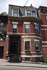
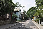
The Pill Hill Historic District is a historic district roughly bounded by Boylston Street, Pond Ave., and Acron, Oakland and Highland Roads in Brookline, Massachusetts.
Excerpt from the Wikipedia article Pill Hill Historic District (License: CC BY-SA 3.0, Authors, Images).Pill Hill Historic District
Upland Road,
Geographical coordinates (GPS) Address Nearby Places Show on map
Geographical coordinates (GPS)
| Latitude | Longitude |
|---|---|
| N 42.328055555556 ° | E -71.120555555556 ° |
Address
Upland Road 78
02445
Massachusetts, United States
Open on Google Maps


