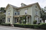
Cypress–Emerson Historic District
Brookline, MassachusettsHistoric districts in Norfolk County, MassachusettsHistoric districts on the National Register of Historic Places in MassachusettsNRHP infobox with nocatNational Register of Historic Places in Brookline, Massachusetts ... and 1 more
Use mdy dates from August 2023

The Cypress–Emerson Historic District encompasses a residential area on the west side of Brookline Village in Brookline, Massachusetts, United States. Centered on Waverly and Cypress Streets, and including Emerson Park, this area was developed in the post-Civil War era, its growth matching that of the commercial areas of the village. The district was listed on the National Register of Historic Places in 1985.
Excerpt from the Wikipedia article Cypress–Emerson Historic District (License: CC BY-SA 3.0, Authors, Images).Cypress–Emerson Historic District
Emerson Street,
Geographical coordinates (GPS) Address Nearby Places Show on map
Geographical coordinates (GPS)
| Latitude | Longitude |
|---|---|
| N 42.332883333333 ° | E -71.122505555556 ° |
Address
Emerson Street 34
02445
Massachusetts, United States
Open on Google Maps


