Anglin
Creuse geography stubsFrance river stubsIndre geography stubsPages with French IPARivers of Centre-Val de Loire ... and 7 more
Rivers of CreuseRivers of FranceRivers of IndreRivers of Nouvelle-AquitaineRivers of VienneTributaries of the CreuseVienne geography stubs

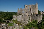
The Anglin (French pronunciation: [ɑ̃ɡlɛ̃]) is a 91.3 km (56.7 mi) long river in the Creuse, Indre and Vienne departments in central France. Its source is near Azerables. It flows generally northwest. It is a right tributary of the Gartempe, into which it flows near Angles-sur-l'Anglin. Its main tributaries are the Salleron, the Abloux and the Benaize. The Anglin is one of France's few remaining "wild rivers" (rivers which have never been dammed). Anglin Castle is an 11th Century castle located high above the banks of the Anglin in the town of Angles-sur-l'Anglin.
Excerpt from the Wikipedia article Anglin (License: CC BY-SA 3.0, Authors, Images).Anglin
D 11, Châtellerault
Geographical coordinates (GPS) Address Nearby Places Show on map
Geographical coordinates (GPS)
| Latitude | Longitude |
|---|---|
| N 46.704166666667 ° | E 0.86583333333333 ° |
Address
D 11
86260 Châtellerault
Nouvelle-Aquitaine, France
Open on Google Maps


