Ma Wan Channel

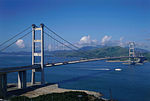
Ma Wan Channel (Chinese: 馬灣海峽) is a channel between Ma Wan and Tsing Yi islands in Hong Kong. The north end of the channel is Ting Kau where it joins the Rambler Channel. To the west it joins with the Kap Shui Mun channel running to the south of Ma Wan, leading into Urmston Road. To the east, it divides into the Tsing Yi Channel and the Rambler Channel, leading to Tsuen Wan and Kwai Chung. To the south is the Western Working Anchorage of Victoria Harbour. A long suspension bridge, the Tsing Ma Bridge, connects Ma Wan and Tsing Yi, bridging across the Ma Wan channel. One of the bridge towers stands on an artificial island near the Ma Wan side of the channel.Historically, it is also known as Kai Tap Mun (雞踏門) or Kai Tsap Mun (雞閘門).
Excerpt from the Wikipedia article Ma Wan Channel (License: CC BY-SA 3.0, Authors, Images).Ma Wan Channel
Lantau Link,
Geographical coordinates (GPS) Address Nearby Places Show on map
 Continue reading on Wikipedia
 Geographical coordinates (GPS)
| Latitude | Longitude |
|---|---|
| N 22.348333333333 ° | E 114.07361111111 ° |
Address
青馬大橋 Tsing Ma Bridge
Lantau Link
, 馬灣 Ma Wan
Hong Kong, China
Open on Google Maps