Swyncombe
Civil parishes in OxfordshireHamlets in OxfordshireOxfordshire geography stubsUse British English from August 2015

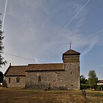
Swyncombe is a hamlet and large civil parish in the high Chilterns, within the Area of Outstanding Natural Beauty about 4+1⁄2 miles (7 km) east of Wallingford, Oxfordshire, England. Swyncombe hamlet consists almost entirely of its Church of England parish church of Saint Botolph, the former rectory and Swyncombe House. The population of the parish is in the hamlets of Cookley Green and Russell's Water, and the scattered hamlet of Park Corner. The 2011 Census recorded the parish's population as 250. It is partially forested and is the fifth largest of 87 civil parishes in the District.
Excerpt from the Wikipedia article Swyncombe (License: CC BY-SA 3.0, Authors, Images).Swyncombe
Rectory Hill, South Oxfordshire
Geographical coordinates (GPS) Address Nearby Places Show on map
Geographical coordinates (GPS)
| Latitude | Longitude |
|---|---|
| N 51.606 ° | E -1.015 ° |
Address
Rectory Hill
RG9 6EA South Oxfordshire
England, United Kingdom
Open on Google Maps


