Wilby, Suffolk
Civil parishes in SuffolkMid Suffolk DistrictVillages in Suffolk

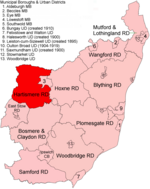
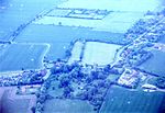
Wilby is a village and civil parish in the Mid Suffolk district of Suffolk in eastern England located around 9 miles (14 km) south-east of Diss and 1.25 miles (2 km) south of Stradbroke along the B1118. The population of the parish at the 2001 census was 231 in 99 households. The village has some basic services including a primary school and village hall.The nearest villages are Brundish, Laxfield, Stradbroke and Worlingworth. Foals Green, Russel's Green, Stanway Green and Wootten Green (part) form part of the village which is dispersed in nature.
Excerpt from the Wikipedia article Wilby, Suffolk (License: CC BY-SA 3.0, Authors, Images).Wilby, Suffolk
Church Road, Mid Suffolk
Geographical coordinates (GPS) Address Nearby Places Show on map
Geographical coordinates (GPS)
| Latitude | Longitude |
|---|---|
| N 52.301 ° | E 1.286 ° |
Address
Church Road
IP21 5LJ Mid Suffolk
England, United Kingdom
Open on Google Maps


