place

Central Quebec School Board

1998 establishments in QuebecEducation in Quebec CityEducational institutions established in 1998Quebec Anglophone culture in Quebec CityQuebec English School Boards Association
Quebec school stubsSchool districts in Quebec
Logo Central Quebec School Board

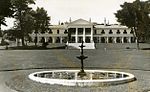
The Central Québec School Board (CQSB; French: Commission scolaire Central Québec) is an English-language school board in the province of Quebec, Canada, with its headquarters at 2046 chemin Saint-Louis, Quebec City. It is one of nine English-language school boards in the province, having served the English-speaking community, under various names, since 1867.As a school board, CQSB's jurisdiction covers the largest territory in the province of Quebec, at 493,495 kilometres (306,644 miles). The Central Québec School Board administers 18 schools and one adult and vocational education centre. In 2012, eight of its nine secondary schools had a student population of less than 500. CQSB's largest elementary school served almost 500 students, and its smallest one served less than 60 students in 2012.

Excerpt from the Wikipedia article Central Quebec School Board (License: CC BY-SA 3.0, Authors, Images).

Central Quebec School Board
Chemin Saint-Louis, Quebec Sillery (Sainte-Foy–Sillery–Cap-Rouge)

Geographical coordinates (GPS) Address Phone number Website External links Nearby Places
placeShow on map

Wikipedia: Central Quebec School BoardContinue reading on Wikipedia

Geographical coordinates (GPS)

Latitude Longitude
N 46.778352 ° E -71.251869 °
placeShow on map

Address

Commission scolaire Central Québec

Chemin Saint-Louis 2046
G1T 1P4 Quebec, Sillery (Sainte-Foy–Sillery–Cap-Rouge)
Quebec, Canada
mapOpen on Google Maps

Phone number

call+14186888730

Website
cqsb.qc.ca

linkVisit website

linkWikiData (Q2986738)
linkOpenStreetMap (2104715327)

Logo Central Quebec School Board
Share experience

Nearby Places

Mount Hermon Cemetery

Mount Hermon Cemetery is a garden (or rural) cemetery and National Historic Site of Canada. It is located in the Sillery district (French: quartier) of the Sainte-Foy–Sillery–Cap-Rouge borough (French: arrondissement) of Quebec City, Quebec, Canada. The cemetery was designated a National Historic Site of Canada in 2007.The impetus for the creation of the 11-hectare (26-acre) cemetery was the need for the provision of an Anglican burying ground for Quebec City's primarily English language speaking, Anglican community, in the mid–1800s.The cemetery is located at the corner of Saint-Louis Road (French: chemin Saint-Louis) and côte de Sillery (formerly côte de l'Église), on 109,010 m2 (0.042 sq mi) of land overlooking the Saint Lawrence River, in the southeastern direction.More than 17,000 people are buried at Mount Hermon. Mount Hermon Cemetery draws distinction as being the first garden cemetery (French: cimetière-jardin) established in Canada. Mount Hermon, and other garden cemeteries formed in North America, took inspiration from cimetière du Père-Lachaise of Paris.A memorial was dedicated to the victims of the sinking of the shipwrecked Empress of Ireland, in 1914, and other memorials were erected at later dates on the cemetery's grounds. The major loss of lives aboard the shipwrecked Empress of Ireland had significant impact upon Mount Hermon, along with its neighboring cemetery on chemin Saint-Louis: Saint-Patrick's Cemetery, which also relocated from the city of Quebec, in 1879. Both of the cemeteries took on responsibility for a significant number of the ship's passengers whom perished aboard or at sea. Separately, on the Mount Hermon grounds is the Treggett Bell, which was presented in gratitude to the Treggett family, who had members from four different generations of its family serve as Mount Hermon's Superintendents, encompassing the years 1865–2014.In addition, the cemetery contains sections dedicated for individuals of Greek (French: section de la communauté grecque orthodoxe), Chinese (French: section de la communauté chinoise), and Cambodian (French: lots des cambodgiens) descent.The main entrance is accessed at 1801 Saint-Louis Road, at the northern end of the cemetery. There is a pedestrian entrance located at the southwestern portion of the cemetery, accessed at the northern terminus of avenue des Voiliers, one-block east of côte de Sillery. The cemetery grounds contain both paved and gravel roads.

Sillery, Quebec City

Sillery, a former independent city founded in 1637, is one of 35 administrative sectors (French: quartiers), which are unincorporated places, located in the post-expansion jurisdiction of the City of Quebec, Quebec, Canada. Sillery was one of multiple self-governing municipalities amalgamated into a vastly expanded Quebec City, that went into legal effect on January 1, 2002, as part of the province-wide 2000–06 municipal reorganization in Quebec. Located alongside in what pre-merger was the southwestern border of Quebec City, Sillery is a constituent district (French: quartier) of the borough (French: arrondissement) of Sainte-Foy–Sillery–Cap-Rouge. The territorially expanded City of Quebec consists of six boroughs. Four heritage sites are located within Quebec City, one of which is situated in Sillery. The neighbourhood of Sillery contains the Sillery Heritage Site, which was recognized as heritage district by the provincial government on 5 February 1964. On 22 June 2006, the federal government's Parks Canada included Sillery's historic district on its Canadian Register of Historic Places. In 2013, Quebec City changed the name of the historic district to Sillery Heritage Site (French: site patrimonial de Sillery), as part of its preparation for the provincial government's transfer of responsibility for the district's management to it.The City of Quebec has 27 neighbourhood councils (French: conseils de quartiers) spread across its territorial jurisdiction. Sillery has city representation and citizen participation through le conseil de quartier de Sillery. The council has public meetings, at Sillery's community centre, which on average are scheduled once a month. Sillery elects a total of 10 board members in staggered terms of office holding.

Anse au Foulon
Anse au Foulon

Anse au Foulon (English: Fuller's Handle) is a small cove in Quebec, Canada. It was located about one and one-half miles above Quebec City, in the formerly independent town of Sillery, until the 1st of January 2002, as part of the 2000–06 municipal reorganization in Quebec. Since that date, Anse au Foulon and Sillery (reconstituted as a neighbourhood (quartier)) have been officially located in Quebec City. The cove was known and referred to as Wolfe's Cove by Sillery's once-sizable English-speaking population. The first written reference to this appellation pertains to the event which took place at the cove and its cliff in 1759.On the night of 12 September 1759, and early morning hours on the 13th, British forces commanded by James Wolfe landed at Anse au Foulon, prior to proceeding to the Plains of Abraham, where they engaged and defeated the French forces commanded by the Marquis de Montcalm, resulting in the occupation of Quebec City, and the subsequent signing of the Treaty of Paris (1763). The treaty marked Great Britain's victory over France and Spain, during the Seven Years' War, and stipulated France's ceding of New France east of the Mississippi River to Great Britain. The etymology of the toponym originates from a fulling mill (French: foulon) that the Séminaire de Québec built in 1710, at the base of the cliff which met the cove. The mill's workers traveled on a path that became known as Foulon path (chemin du Foulon), as well as its plural (des Foulons). Despite the closure of the mill in 1734, the toponym of Foulon persisted. It was not until 1924, that the town of Sillery adopted the name of chemin du Foulon (also referred to a Cove Road) for the path turned into road. On 5 December 1968, the Commission de toponymie du Québec recognized Wolfe's Cove as the topographic feature's official name; however, this decision was superseded on 17 August 1978, when the commission recognized Anse au Foulon as the official name.