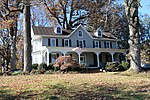
Waverly (Marriottsville, Maryland)

Waverly Mansion is a historic home located at Marriottsville in Howard County, Maryland, USA. It was built circa 1756, and is a 2+1⁄2-story Federal style stone house, covered with stucco, with a hyphen and addition that date to circa 1811. Also on the property are a small 1+1⁄2-story stone overseer's cottage and a 2-story frame-and-stone barn, and the ruins of a log slave quarter.Waverly was a property developed on land first patented by Charles Carroll of Carrollton and later part of the 1703 survey "Ranter's Ridge" owned by Captain Thomas Browne. The land was resurveyed in 1726 as "The Mistake." It was purchased by John Dorsey and deeded to his son and daughter-in-law, Nathan and Sophia Dorsey as the next owners.The property is associated with the Dorsey and Howard families. From the time it was established through the end of the Civil War, Waverly functioned as a plantation where unpaid slave labor was used for farm operations and creation of the wealth and lifestyle afforded to the Dorsey and Howard families. Through deeds, census records and an inventory taken upon the death of George Howard in 1846, information about the enslaved population at Waverly was uncovered. A 1965 article in the Ellicott City Times claimed that 999 slaves worked on the plantation at one time, but research has shown that between 7 and 25 enslaved men, women and children is more accurate. The Ellicott City Times article does not have any primary sources to back up this claim, nor is there an author's name credited to the article.
Excerpt from the Wikipedia article Waverly (Marriottsville, Maryland) (License: CC BY-SA 3.0, Authors, Images).Waverly (Marriottsville, Maryland)
Austen Way,
Geographical coordinates (GPS) Address Website Nearby Places Show on map
Geographical coordinates (GPS)
| Latitude | Longitude |
|---|---|
| N 39.31 ° | E -76.895 ° |
Address
Waverly Woods Golf Course
Austen Way
21163
Maryland, United States
Open on Google Maps


