place

Columbia River Shipbuilding Company

1918 establishments in Oregon1920 disestablishments in OregonCompanies based in Portland, OregonDefunct companies based in OregonDefunct shipbuilding companies of the United States
History of transportation in OregonManufacturing companies disestablished in 1920Manufacturing companies established in 1918Shipbuilding companies of Oregon
USAT Will H. Point, 21 August 1943

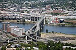
The Columbia River Shipbuilding Company was a small shipyard in Portland, Oregon, United States, located on the west bank of the Willamette River. The shipyard was located at the foot of SW Sheridan Street, just upstream of the Interstate 5 Marquam Bridge, directly adjacent to the Northwest Steel shipyard. The owners of Columbia River Shipbuilding were A. F. Smith and J. Frank Watson, who were also owners of the Smith and Watson Iron Works. The shipyard was managed by Charles D. Bowles, who was also associated with J. F. Duthie Shipbuilding of Seattle, Washington. Columbia River Shipbuilding was established in 1918 to build cargo ships for the United States Shipping Board (USSB). The shipyard closed shortly after the end of World War I. Most of the 32 ships built by the Columbia River Shipbuilding Company were the West boats, a series of 5,600-gross register ton (GRT) steel-hulled cargo ships built for the USSB on the West Coast of the United States as part of the World War I war effort. The first ship built at Columbia River Shipbuilding was the cargo ship Westward Ho; the final ship completed was the cargo ship West Hassayampa, completed in January 1920.

Excerpt from the Wikipedia article Columbia River Shipbuilding Company (License: CC BY-SA 3.0, Authors, Images).

Columbia River Shipbuilding Company
South Bond Avenue, Portland South Portland

Geographical coordinates (GPS) Address Nearby Places
placeShow on map

Wikipedia: Columbia River Shipbuilding CompanyContinue reading on Wikipedia

Geographical coordinates (GPS)

Latitude Longitude
N 45.50603 ° E -122.67048 °
placeShow on map

Address

South Bond Avenue

South Bond Avenue
97258 Portland, South Portland
Oregon, United States
mapOpen on Google Maps

USAT Will H. Point, 21 August 1943
Share experience

Nearby Places

Northwest Steel
Northwest Steel

Northwest Steel was a structural steel fabricator and shipbuilding company in Portland, Oregon. During World War I the yard built cargo ships for the United States Shipping Board (USSB). Some 37 of the 46 ships ship built at Northwest Steel were the West boats, a series of 5,500-gross register ton (GRT) steel-hulled cargo ships built for the USSB on the West Coast of the United States as part of the World War I war effort.The Northwest Steel Company was incorporated in August 1903.In July 1913, NW Steel began construction of a new plant, to be complete February 1914, after its present site was purchased by the public dock commission. Location of the new plant is a newly built 300x350 feet dock. Planned are a 60x800-foot main shop, 50x100-foot blacksmith shop, 50x100-foot machine shop and a 50x100-foot template shop.Work on shipyard facilities began with dredging on April 1, 1916. everything built was as extensions of the existing company plant. The mold loft was begun the first week of May, the ways were constructed starting in late May. The first keel was hurried and laid down on July 9, 1916 with some improvisation in the still not fully finished yard. Eventually there was also a large rivet and bolt shop erected to handle the demand, including for boat spikes of the numerous wooden hull constructors in the vicinity, production for the boat spikes alone amounting to 14 tons a day in 1918. See also: 1921 Industrial Map of Portland. The shipyard was sandwiched between the river to the east, the yard of the Columbia River Shipbuilding Company to the south, railroad tracks to the west and the Portland Lumber Company mill to the north. Northwest Steel was the largest of the 4 steel shipyards in the Portland / Vancouver region. In May 1918, contracts were awarded for a $17,500 mold loft to be built at the company's site at the foot of Sheridan Street. In July 1918, NW Steel planned to build 4 additional slipways at its plant site.In February 1919 it was announced that Northwest Steel had retired from the structural steel field. The Northwest Bridge & Iron Co., headed by W.H. Cullers, was taking over this end of the business and was looking for a new plant site. In January 1920, Bridge & Iron took over the rest of Northwest Steel's business.It was headed by Joseph R. Bowles, who was indicted for bribing a government official in about 1918 and then convicted of contempt of court. He was later described as a "greedy, domineering and difficult person, with no sense of civic responsibility."The first ship built at Northwest Steel was the cargo ship War Baron, originally launched on March 31, 1917, as the Cunard Line ship Vesterlide, a British-flagged ship sunk by German submarine U-55 in January 1918. The final ship built was the 8,200 GRT tanker Swiftwind, completed in June 1921. 31 Men Tackle City Wood Yards Thirty-one men reported this morning for work in the municipal woodyard, located in the sheds of the old Northwestern Steel Company, foot of Sheridan Street. The yard was opened upon recommendation of the mayor's committee on unemployment to allow men who need board and lodging an opportunity to earn it without loss of self respect by begging. Oregon Daily Journal, December 20, 1921

Marquam Bridge
Marquam Bridge

The Marquam Bridge is a double-deck, steel-truss cantilever bridge that carries Interstate 5 traffic across the Willamette River south of downtown Portland, Oregon. It is the busiest bridge in Oregon, carrying 140,500 vehicles a day as of 2016. The upper deck carries northbound traffic; the lower deck carries southbound traffic. The bridge was designed and built by the Oregon Department of Transportation at a cost of $14 million, equivalent to $117 million today. Construction on the bridge's support piers began in January 1962. The lower southbound deck was opened on October 4, 1966, and the upper northbound deck on October 18, 1966. The main span of the bridge is 440 ft (130 m) long and the two side spans are 301 ft (92 m) each. Vertical clearance of the lower deck is 130 feet (40 m) and the upper deck is 20 feet (6.1 m) above the lower. It is named after Philip Marquam, a state legislator and Multnomah County judge, who owned much of Marquam Hill where Oregon Health & Science University and the Veterans Affairs Medical Center now stand. At the eastern end of the bridge, on the lower deck, is a ramp stub which was intended to connect to the abandoned Mount Hood Freeway. As it has great importance, the Marquam was the first Portland bridge to undergo a seismic retrofit in 1995. The Marquam Bridge was built with economy in mind and the public at large reacted unfavorably to the structure's bland aesthetics, which included a formal protest from the Portland Arts Commission. (In particular, it blocked the view of downtown from the Union Avenue Viaduct.) This led to public input in the design of the Fremont Bridge. During Mayor Vera Katz's State of the City address in 2001, she said, "It’s like having the Berlin Wall dividing east and west, with all the subtle charm of the Daytona 500 smack dab in the middle of our city." The bridge was designed with three lanes in each direction with shoulders on each deck. Today, it carries four narrow lanes and no shoulders on each deck. Options historically considered have been to reroute I-5 over the existing I-405 alignment, connecting I-84 to I-5 at the Fremont Bridge interchange, following the US 30 alignment, and removing the Marquam permanently. Another option would build a tunnel under the Willamette River approximately following the existing I-5 alignment, and remove the Marquam Bridge permanently.Proposals have been made to replace the Eastbank Freeway portion of I-5 with a tunnel, connecting with the existing alignment at the Marquam Bridge and the Rose Quarter. This would free up space along the Willamette River for development.