place

Statham's Quarry

1894 establishments in AustraliaGeology of Western AustraliaGooseberry Hill, Western AustraliaQuarries in AustraliaState Register of Heritage Places in the City of Kalamunda
Use Australian English from March 2014
Stathams 9
Stathams 9

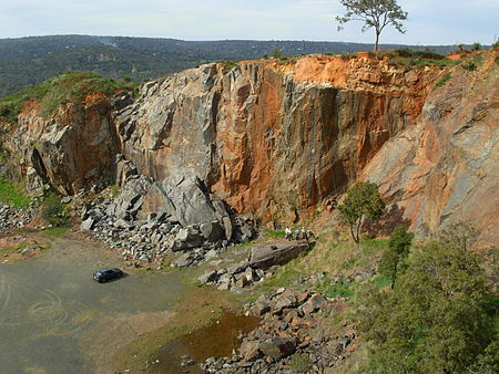
Statham's Quarry (also known as Darling Range Quarry, and then Perth City Council's Darling Range Quarry after 1920) is the site of a quarry on the Darling Scarp on the southern side of the entrance of the Helena River valley on to the Swan Coastal Plain in Perth, Western Australia. It is located in Gooseberry Hill and is within the bounds of the Gooseberry Hill National Park.

Excerpt from the Wikipedia article Statham's Quarry (License: CC BY-SA 3.0, Authors, Images).

Statham's Quarry
Statham's Quarry Access Track, City Of Kalamunda

Geographical coordinates (GPS) Address Nearby Places
placeShow on map

Wikipedia: Statham's QuarryContinue reading on Wikipedia

Geographical coordinates (GPS)

Latitude Longitude
N -31.934247 ° E 116.048184 °
placeShow on map

Address

Statham's Quarry Access Track

Statham's Quarry Access Track
6070 City Of Kalamunda, Gooseberry Hill
Western Australia, Australia
mapOpen on Google Maps

Stathams 9
Stathams 9
Share experience

Nearby Places

Gooseberry Hill, Western Australia

Gooseberry Hill is a suburb of Perth, Western Australia, located within the City of Kalamunda. It is the site of Gooseberry Hill National Park. It is located at the highest point south of the departure of the Helena River from the Darling Scarp on to the Swan Coastal Plain. It is often associated with the railway formation of the Kalamunda Zig Zag and the northernmost high feature of Statham's Quarry, which lie on the north west of the locality within national park land. In 1861, Benjamin Robins purchased 40 acres (16 ha) of land in the area. In 1878 surveyor Henry Samuel Ranford recorded the name of the eponymous hill as "Gooseberry Hill" ; that name, derived from the presence of cape gooseberries in the area, referred to the Kalamunda area generally in the late 19th century. The townsite was officially gazetted on 8 June 1959.Gooseberry Hill was the location of a war-time tragedy when a United States Navy C-47 Skytrain (DC-3) plane crashed in heavy fog on 19 April 1945 after taking off from Guildford Airport (later Perth Airport). All of the ten US servicemen and three US Red Cross women on board were killed. The plane crashed between Gooseberry Hill Road and Lansdown Road, 4.5 miles (7.2 km) from the end of the take-off runway, having travelled in an almost straight course to the point of impact.The suburb contains two schools, Gooseberry Hill Primary School, a government school established in 1972, and Mary's Mount Primary School, a Catholic school established in 1921.

Greenmount National Park

Greenmount National Park is a national park in the locality of Greenmount, Western Australia, 22 km east of Perth. It is one of the smaller national parks along the Darling Scarp and is a component of the Darling Range Regional Park. Due to its proximity to John Forrest National Park, which used to be known as Greenmount National Park until 1928, and relationship to subsequent reserves to the south it is a vital scarp wildlife corridor. Bus tours were available from Perth in 1933 with Hill's Bus Tours offering passengers a tour around the park on Sundays in September. Beam Transport Ltd. offered a similar service through the Park to Mundaring Weir in 1937.As a feature adjacent to the Helena River Valley it has significance in Aboriginal folklore, and also featured very early on in early European settler's diaries. Mountain Quarry is one of several blue stone quarries located within the park, popular with rock climbers and walkers. Vehicle access to the quarry site is restricted; however a car-park and picnic facilities including toilets are within walking distance of the main site, which is completely accessible on foot. There are several panels containing historical information about the site spread around as part of the popular Railway Reserves Heritage Trail, which runs close to the quarry. The Boya/Koongamia leg of the Railway Reserves Heritage Trail, also known as the "Bridle Trail", curves around the south-western edge of the park, crossing through the Mountain Quarry car-park and picnic area. In the early 2000s significant bushfire damage occurred on the southern slopes of this park. Large fire-breaks bisect the park, serving as popular walking routes among locals. The western and northern slopes, visible from Great Eastern Highway, have extensive Watsonia infestations. In late 2005, the government authority in charge of the national park was taking steps to prevent vehicular access along the top of the ridge to the lookout due to vandalism and issues with residents adjacent to the park.The park is situated along the side of Greenmount Hill and has views over the Swan Coastal Plain below and Perth to the west. The dominant vegetation in the park is eucalypts such as marri and wandoo along with an array of wild flowers and heathland along the northern slopes. The hill is steep and contain several breakaways and rocky outcrops.