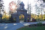
Rogers Fort Hill Park Historic District

The Rogers Fort Hill Park Historic District of Lowell, Massachusetts, encompasses the largest single residential development made in the city in the 19th century. The district includes the area historically associated with the Rogers Farm, purchased in 1805 by Zadock Rogers. His daughters sold off most of the property in two parcels in the 1880s: land to the south of their homestead was sold to the city, and most of it was developed into Fort Hill Park, while that north of the homestead was sold to developers. The district is roughly bounded by High Street, Mansur Street, Concord Road, and Lowell Cemetery. The district was added to the National Register of Historic Places in 1999.
Excerpt from the Wikipedia article Rogers Fort Hill Park Historic District (License: CC BY-SA 3.0, Authors, Images).Rogers Fort Hill Park Historic District
Park Avenue East, Lowell
Geographical coordinates (GPS) Address Nearby Places Show on map
Geographical coordinates (GPS)
| Latitude | Longitude |
|---|---|
| N 42.635 ° | E -71.296388888889 ° |
Address
Park Avenue East 4
01852 Lowell
Massachusetts, United States
Open on Google Maps


