place

Wellesley Hills Branch Library

Libraries in Norfolk County, MassachusettsLibraries on the National Register of Historic Places in MassachusettsLibrary buildings completed in 1927National Register of Historic Places in Norfolk County, MassachusettsNorfolk County, Massachusetts Registered Historic Place stubs
Wellesley, Massachusetts
Wellesley Hills Branch Library MA 03

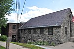
The Wellesley Hills Branch Library is a historic library building at 210 Washington Street in Wellesley, Massachusetts. The stone building was designed in 1927 by Hampton F. Shirer, whose plans were developed from the sketches of the late Ralph H. Hannaford, and completed in 1928. The Colonial Revival building is L-shaped, with single story above a raised basement. It is faced in local fieldstone. The main block has a five-bay side-gable configuration with a projecting entry pavilion. It is the town's first purpose-built branch library. The building was listed on the National Register of Historic Places in 2007.

Excerpt from the Wikipedia article Wellesley Hills Branch Library (License: CC BY-SA 3.0, Authors, Images).

Wellesley Hills Branch Library
Washington Street,

Geographical coordinates (GPS) Address Phone number Website External links Nearby Places
placeShow on map

Wikipedia: Wellesley Hills Branch LibraryContinue reading on Wikipedia

Geographical coordinates (GPS)

Latitude Longitude
N 42.314722222222 ° E -71.270972222222 °
placeShow on map

Address

Wellesley Hills Branch Library

Washington Street 210
02481 , Wellesley Hills
Massachusetts, United States
mapOpen on Google Maps

Phone number

call+17812370381

Website
wellesleyfreelibrary.org

linkVisit website

linkWikiData (Q7981249)
linkOpenStreetMap (217052873)

Wellesley Hills Branch Library MA 03
Share experience

Nearby Places

Newton Lower Falls Historic District

The Newton Lower Falls Historic District encompasses the historic colonial village center of Newton Lower Falls, on the west side of Newton, Massachusetts. This area lies north of Washington Street, along Concord and Grove Streets, between Washington and Hagar Streets. The district was listed on the National Register of Historic Places in 1986.The "lower falls" of the Charles River were an important geographic even before colonial days, because a Native American path traversed the area (roughly along the Washington Street alignment). In the 17th century the waterpower of the falls was already being harnessed by English colonists for the operation of gristmills and sawmills. Permanent residency on the Newton side of the river did not begin until the early 18th century, when an iron works was established. The oldest surviving house in the area is at 2345 Washington Street, built c. 1755. The residential portion of the village developed on the rise above the river, where St. Mary's Episcopal Church was built c. 1813; it is separately listed on the National Register. Adjacent to the church, a number of Greek Revival houses were built on Grove Street during the 1830s and 1840s, the height of the area's economically significant paper industry. The last significant construction in the district was the hose house (fire station) at 677 Grove Street in 1900.The historic portion of the village, once much larger, suffered a significant decline in the 20th century. Fashionable houses belonging to mill owners were demolished, as were more modest residences of mill workers, in some cases to make way for the construction of nearby Massachusetts Route 128. This intrusion also resulted in the destruction of a church and schools.