place

Leadenham railway station
Disused railway stations in LincolnshireFormer Great Northern Railway stationsRailway stations in Great Britain closed in 1965Railway stations in Great Britain opened in 1867Use British English from August 2015
Leadenham railway station

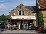
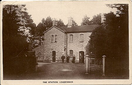
Leadenham railway station was a railway station in Leadenham, Lincolnshire. It closed on 1 November 1965. The station was located on Main Road, being built in 1867 from coursed rubble with flush ashlar dressings along with a slate roof with overhanging eaves. As the station was on the parish border between the Leadenham and Welbourn, Ancaster stone was used for the station and the goods shed and bridge to the north were built of red brick as they fell within the Welbourn parish. The design of the station differed from most of the stations on the line that were built of red brick, but local landowner Lieutenant-General J. Reeve of Leadenham Hall insisted that the station was to be built of local stone. Ordnance Survey maps from 1887 and 1905 show the station building to the west of the railway tracks with a waiting shelter on the opposite platform. There was also a signal box to the north. The old station building is still standing, it is a Grade II listed building which is now a private residence. The goods shed is also still standing and is currently a car dealership, with the gateway to the premises being a re-sited original GNR gate and piers. The bridge to the north is still in use too, but only for road traffic. The signal box and waiting shelter have both been demolished.

Excerpt from the Wikipedia article Leadenham railway station (License: CC BY-SA 3.0, Authors, Images).

Leadenham railway station
A607, North Kesteven Leadenham

Geographical coordinates (GPS) Address Nearby Places
placeShow on map

Wikipedia: Leadenham railway stationContinue reading on Wikipedia

Geographical coordinates (GPS)

Latitude Longitude
N 53.0633 ° E -0.5743 °
placeShow on map

Address

A607
LN5 0PF North Kesteven, Leadenham
England, United Kingdom
mapOpen on Google Maps

Leadenham railway station
Share experience

Nearby Places

Caythorpe, Lincolnshire

Caythorpe is a village and civil parish in the South Kesteven district of Lincolnshire, England. The population at 2011 census was 1,374. It is situated on the A607, approximately 3 miles (5 km) south from Leadenham and 9 miles (14 km) north from Grantham. Caythorpe Heath stretches east of the village to Ermine Street and Byards Leap. Arnhem Heritage: Caythorpe is known for the soldiers based in the village during the Second World War. The 1st Airborne Signals Regiment took part in Operation Market Garden and fought for the bridges of Arnhem against the Nazis. Survivors of the Battle of Arnhem return to the village every late summer with the 216 Signals Regiment for Arnhem Weekend. There is a church service held in Saint Vincents Church, a Gala, parade through the village of the veterans and soldiers and other events in the village. The Paratroopers HQ was Holy Cross House to the south of the village which no longer stands (which was known to be haunted by ‘the grey lady’), now there is a small housing estate. There is a stained glass window memorial in Saint Vincents Church. Anglo-Saxon and Norman History: Before the Norman Conquest, Aelric (son of Mergeat) was the lord of the parish. After the Conquest of England by William the Conqueror the lord (as recorded in the 1086 Domesday Book) was Robert de Vessey. He was most likely rewarded with land by King William I after the invasion as he didn't own land prior. The Domesday Book noted that Caythorpe was in the hundred of Lovden and had a population of 172 (top 20% of settlements recorded).