Shoeburyness Boom

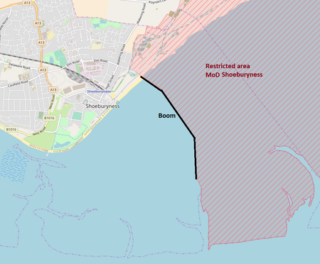
The Shoeburyness Boom (also known as the Sheerness Boom, Thames Boom or Thames Estuary Boom) refers to two successive defensive barriers across most of the Thames Estuary in the mid-20th century. As to the part perpendicular to the north shore most of the latter incarnation remains, and its nearest concrete mooring/patrol point 600 metres south. A 2 km (2,200 yard) stretch, this is designated a scheduled monument and marks the western edge of MoD Shoeburyness firing range, a restricted area. The rest was taken up in the 1960s. The first guise was built in late 1939, the first months of the Second World War, mainly to protect shipping and the capital from attack by submarines, mines and surface vessels. It was dismantled. The second was built between 1950 and 1953 to forestall access to the estuary by Soviet submarines during the Cold War. Both booms ran most of the way from Shoeburyness in Essex to Sheerness in Kent: 5.6 miles (9.0 km). The first guise consisted of wooden piles driven into the estuary bed save for in the deep-water channel which was protected by an anti-submarine net. The second guise added concrete piles at either end of the gap (channel) able to assist Royal Navy vessels. The development of nuclear missiles, jet bombers and the hydrogen bomb quickly rendered the Cold War boom obsolete and it was partially demolished in the 1960s.
Excerpt from the Wikipedia article Shoeburyness Boom (License: CC BY-SA 3.0, Authors, Images).Shoeburyness Boom
Essex
Geographical coordinates (GPS) Address Nearby Places Show on map
Geographical coordinates (GPS)
| Latitude | Longitude |
|---|---|
| N 51.5271 ° | E 0.8148 ° |
Address
Great Wakering
SS3 0DD Essex
England, United Kingdom
Open on Google Maps


