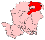
Bentley, Hampshire
EngvarB from October 2023Hampshire geography stubsVillages in Hampshire

Bentley is a village and civil parish in the East Hampshire district of Hampshire, England. The parish has changed little over centuries and currently measures 2,299 acres (9.30 km2), the same size it measured in 1875.: 33 when the population was 731 The village is north of the A31 road between Farnham and Alton, about five miles (8 km) southwest of Farnham and six miles (10 km) northeast of Alton. The village is served by Bentley railway station, which is about one mile (1.6 km) to the south, in the parish of Binsted against Alice Holt Forest. There are two pubs in the village: The Star Inn (named after a car) and The Bull Inn.
Excerpt from the Wikipedia article Bentley, Hampshire (License: CC BY-SA 3.0, Authors, Images).Bentley, Hampshire
Hole Lane, East Hampshire Bentley
Geographical coordinates (GPS) Address Nearby Places Show on map
Geographical coordinates (GPS)
| Latitude | Longitude |
|---|---|
| N 51.19401 ° | E -0.87756 ° |
Address
Hole Lane
Hole Lane
GU10 5LT East Hampshire, Bentley
England, United Kingdom
Open on Google Maps


