Rhine–Meuse–Scheldt delta

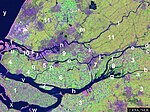
The Rhine–Meuse–Scheldt delta is a river delta in the Netherlands formed by the confluence of the Rhine, the Meuse (Dutch: Maas) and the Scheldt rivers. In some cases, the Scheldt delta is considered a separate delta to the Rhine–Meuse delta. The result is a multitude of islands, branches and branch names, in which a waterway that appears to be one continuous stream may have numerous separate names for different sections, e.g. Rhine → Bijlands Kanaal → Pannerdens Kanaal → Nederrijn → Lek → Nieuwe Maas → Het Scheur → Nieuwe Waterweg. Since the Rhine contributes most of the water, the term "Rhine Delta" is commonly used, although this name is also used for the delta where the Alpine Rhine flows into Lake Constance. By some calculations, the Rhine–Meuse–Scheldt delta covers 25,347 km2 (9,787 sq mi), making it the largest in Europe. The Rhine–Meuse–Scheldt delta is economically extremely important, since the three rivers are major navigable waterways. The delta is the entrance from the North Sea to the German and Central European hinterland (and to a lesser extent France). Major ports in the delta are Rotterdam, Antwerp (Belgium), Vlissingen, Amsterdam (through the Amsterdam–Rhine Canal), and Ghent (through the Ghent–Terneuzen Canal). The land areas in the delta are protected from flooding by the Dutch Delta Works.
Excerpt from the Wikipedia article Rhine–Meuse–Scheldt delta (License: CC BY-SA 3.0, Authors, Images).Rhine–Meuse–Scheldt delta
Deeneplaatweg, Altena
Geographical coordinates (GPS) Address Nearby Places Show on map
Geographical coordinates (GPS)
| Latitude | Longitude |
|---|---|
| N 51.730431 ° | E 4.715881 ° |
Address
Deeneplaatweg
3329 KR Altena
North Brabant, Netherlands
Open on Google Maps
