place

Southease railway station

DfT Category F2 stationsFormer London, Brighton and South Coast Railway stationsLewes DistrictPages with no open date in Infobox stationRailway stations in East Sussex
Railway stations in Great Britain opened in 1906Railway stations served by Govia Thameslink RailwayUse British English from May 2017
Southease
Southease

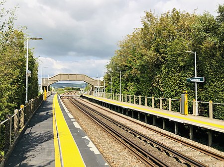
Southease railway station is located 0.5 miles (800 m) east of the village of Southease in East Sussex, England. It is on the Seaford branch of the East Coastway Line, 53 miles 40 chains (86.1 km) measured from London Bridge via Redhill. The station is surrounded by agricultural land. The South Downs Way crosses the Seaford Branch here.

Excerpt from the Wikipedia article Southease railway station (License: CC BY-SA 3.0, Authors, Images).

Southease railway station
Itford Bridge,

Geographical coordinates (GPS) Address Nearby Places
placeShow on map

Wikipedia: Southease railway stationContinue reading on Wikipedia

Geographical coordinates (GPS)

Latitude Longitude
N 50.830555555556 ° E 0.030555555555556 °
placeShow on map

Address

Platform 1

Itford Bridge
BN8 6JS
England, United Kingdom
mapOpen on Google Maps

Southease
Southease
Share experience

Nearby Places

Rodmell
Rodmell

Rodmell is a small village and civil parish in the Lewes District of East Sussex, England. It is located three miles (4.8 km) south-west of Lewes, on the Lewes to Newhaven road and six and a half miles from the City of Brighton & Hove and is situated by the west banks of the River Ouse. The village is served by Southease railway station, opened in 1906. The Prime Meridian passes just to the west of the village. The village name has been variously spelled as Ramelle or Redmelle (11th century), Redmelde (12th century), Radmelde (13th century) and Radmill (18th century). It most likely derives from Brittonic where Rhod denotes a wheel and Melin refers to a Mill, hence mill wheel. A less likely derivation is from Old English read *mylde, "[place with] red soil". Before the time of the Norman conquest the manor of Rodmell was held by King Harold II. At the time the Domesday Book was compiled, there was a church in Rodmell, which was granted to Lewes Priory by William de Warenne, 2nd Earl of Surrey. The early Norman church is dedicated to St. Peter. The font is believed to be Saxon, predating the building itself. More recently, Monk's House was the home of the author Virginia Woolf for twenty-one years until her death in 1941. The village is bisected by the road from Lewes to Newhaven which passes through Iford. This road also passes the neighbouring village of Southease. The village was part of the Holmstrow hundred until the abolition of hundreds in the 19th century.

Lewes and Laughton Levels

The Lewes and Laughton Levels are an area of low-lying land bordering the River Ouse near Lewes and the Glynde Reach near Laughton in East Sussex, England. The area was probably a tidal inlet in Norman times, but by the early 14th century, some meadows had been created by building embankments. Conditions deteriorated later that century, and by 1537, most of the meadows were permanently flooded. Part of the problem was the buildup of shingle across the mouth of the Ouse, but in 1537 a scot tax was raised, and a new channel cut through the shingle. By the mid 17th century, shingle was again preventing the region from draining properly, until the new channel was reinstated around 1731. In 1758 John Smeaton surveyed the area with a view to improving it for agriculture. He suggested straightening and widening the river channel, raising the banks around meadows, and building a large sluice near Piddinghoe, to keep the tides out. Some dredging and widening were carried out, but the straightending and sluice were discarded. In 1788, William Jessop surveyed the whole river, with the main object of improving navigation. The Ouse above Lewes became the River Ouse Navigation, with 19 locks, and for the lower river, he suggested radical straightening, and removal of the shingle bar near the mouth of the river. The work was overseen by a Lewes schoolmaster and civil engineer, and was completed in 1795. Similar treatment of the Glynde Reach occurred between 1796 and 1803, and as well as enabling ships to reach Lewes, the faster moving tides drained the meadows much more effectively. Improvements continued in the early 19th century under the leadership of John Ellman, a renowned agriculturalist who became the Expenditor for the Lewes and Laughton Levels. Severe floods occurred in 1829, but the meadows drained within 48 hours. Management of the flood defences for the Levels passed to the River Ouse Catchment Board in 1939, following the passing of the Land Drainage Act 1930. After three reorganisations and the subsequent privatisation of the water industry, responsibility passed to the Environment Agency, who suggested in 2012 that the land drainage functions should be managed by a local internal drainage board. Lewes District Council objected, and agreed to fund flood and coastal erosion management after the Environment Agency's internal drainage district for the Ouse was formally abolished from 31 March 2017.
South Heighton
South Heighton

South Heighton is a village and civil parish in the Lewes District of East Sussex, England. The village is seven miles (12 km) south of Lewes. In the 1890s the village's population grew from less than 100 to over 500 after a cement manufacturing plant opened nearby. The village is now associated with the urbanised area of Newhaven. There is no place called North Heighton although part of the South Downs above the village is called Heighton Hill, from which one can get to Norton, which lies north-east of South Heighton, and north of Bishopstone. It is a regular thoroughfare and point of rest for ramblers, and features a series of ponds, known locally as 'The Three Lakes', which were until the early 1990s open to the public. It remains a popular destination for local visitors, with its public house, The Hampden Arms, and until recently, its corner-shop and post office, which has now closed and been converted into a residential dwelling. South Heighton is one of many villages in the area which maintains a bonfire society, celebration and parade. South Heighton is famous for its secret tunnels, built and used for defence during the Second World War, which lie underneath most of the village, with the main entrance at Denton House. In 1998, when work finished on the conversion of Denton House into flats and of the surrounding area into houses, the road was called Forward Close, after the ship associated with Newhaven and the secret tunnels, HMS Forward. Notable residents, past and present, include Ralph Reader, originator of the Scouting Gang Show and Ursula Mommens, the great-granddaughter of Charles Darwin and the great-great-granddaughter of the potter Josiah Wedgwood.