place

Codman Square District

Boston Registered Historic Place stubsDorchester, BostonHistoric districts in Suffolk County, MassachusettsHistoric districts on the National Register of Historic Places in MassachusettsNRHP infobox with nocat
National Register of Historic Places in Boston
BostonMA CodmanSquare

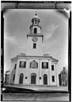
The Codman Square District is a historic district in the Dorchester neighborhood of Boston, Massachusetts. It consists of four of the most prominent properties facing the main Codman Square intersection, where Talbot Avenue and Washington Street cross. The area has a long history as a major civic center in Dorchester, and is now one of the large neighborhood's major commercial hubs. The properties in the district include the 1806 Congregational Church (now known as Second Church of Dorchester), the 1904 Codman Square branch of the Boston Public Library, the former Girls Latin Academy building (built in 1900 as Dorchester High School), and the Lithgow Building, a commercial brick structure at the southeast corner of the junction that was built in 1899.The district was listed on the National Register of Historic Places in 1983.

Excerpt from the Wikipedia article Codman Square District (License: CC BY-SA 3.0, Authors, Images).

Codman Square District
Talbot Avenue, Boston Dorchester

Geographical coordinates (GPS) Address Nearby Places
placeShow on map

Wikipedia: Codman Square DistrictContinue reading on Wikipedia

Geographical coordinates (GPS)

Latitude Longitude
N 42.290277777778 ° E -71.071111111111 °
placeShow on map

Address

Talbot Avenue 374
02124 Boston, Dorchester
Massachusetts, United States
mapOpen on Google Maps

BostonMA CodmanSquare
Share experience

Nearby Places

Ashmont, Boston
Ashmont, Boston

Ashmont is a section of the Dorchester neighborhood of Boston. It includes the subsections of Ashmont Hill, Peabody Square, and Ashmont-Adams. Located near the Milton/Boston border, major streets include Ashmont Street, Gallivan Blvd., and Dorchester Avenue. The neighborhood was developed after Dorchester's annexation to Boston in 1870. The westerly side of the neighborhood, north of Fuller Street and west of Dorchester Avenue, north to Welles Avenue, was laid out on the former Welles estate. The more easterly side of the neighborhood, east of the station, south of Ashmont Street, and north of Minot Street and Van Winkle Street was developed by the Carruth family on their former estate. The neighborhood is known for its larger Victorian style houses on the former estates with other side streets such as Fuller, Burt, Dracut, and Wrentham Streets having a denser two and three family development pattern. Dorchester Avenue in the area has an urban neighborhood commercial development pattern. The MBTA has Red Line direct subway service to Downtown Boston, Harvard Square and other Cambridge locations (and ultimately to Alewife Station) at the Ashmont station and there is a link to the Ashmont–Mattapan High Speed Line trolley going to Mattapan. All Saints Church, an Episcopal Church in Ashmont was designed by the architect Ralph Adams Cram and dedicated in 1892. It is listed on the National Register of Historic Places. Ashmont Hill Architectural Conservation District is a pending Boston Landmark.