place

Broadway–Flushing, Queens

1906 establishments in New York CityCommons link is the pagenameFlushing, QueensHistoric districts in Queens, New YorkHistoric districts on the National Register of Historic Places in Queens, New York
Neighborhoods in Queens, New York
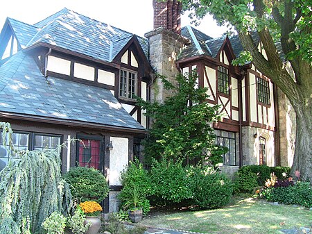
House in Broadway Flushing

Broadway–Flushing is a historic district and residential subsection of Flushing, Queens, New York City. The neighborhood comprises approximately 2,300 homes. It is located between 155th and 170th Streets to the west and east respectively, and is bounded on the north by Bayside and 29th Avenues, and on the south by Northern Boulevard and Crocheron Avenue. Broadway–Flushing is listed on the National Register of Historic Places.

Excerpt from the Wikipedia article Broadway–Flushing, Queens (License: CC BY-SA 3.0, Authors, Images).

Broadway–Flushing, Queens
162nd Street, New York Queens County

Geographical coordinates (GPS) Address Nearby Places
placeShow on map

Wikipedia: Broadway–Flushing, QueensContinue reading on Wikipedia

Geographical coordinates (GPS)

Latitude Longitude
N 40.763333333333 ° E -73.803333333333 °
placeShow on map

Address

162nd Street 35-71
11358 New York, Queens County
New York, United States
mapOpen on Google Maps

House in Broadway Flushing
Share experience

Nearby Places

Flushing, Queens
Flushing, Queens

Flushing is a neighborhood in the north-central portion of the New York City borough of Queens. The neighborhood is the fourth-largest central business district in New York City. Downtown Flushing is a major commercial and retail area, and the intersection of Main Street and Roosevelt Avenue at its core is the third-busiest in New York City, behind Times Square and Herald Square.Flushing was established as a settlement of New Netherland on October 10, 1645, on the eastern bank of Flushing Creek. It was named Vlissingen, after the Dutch city of Vlissingen. The English took control of New Amsterdam in 1664, and when Queens County was established in 1683, the "Town of Flushing" was one of the original five towns of Queens. In 1898, Flushing was consolidated into the City of New York. Development came in the early 20th century with the construction of bridges and public transportation. An immigrant population, composed mostly of Chinese and Koreans, settled in Flushing in the late 20th century. Flushing contains numerous residential subsections, and its diversity is reflected by the numerous ethnic groups that reside there. Flushing is served by several stations on the Long Island Rail Road's Port Washington Branch, as well as the New York City Subway's IRT Flushing Line (7 and <7>​ trains), which has its terminus at Main Street. Flushing is located in Queens Community District 7, and its ZIP Codes are 11354, 11355, and 11358. It is patrolled by the New York City Police Department's 109th Precinct.

Travis Triangle
Travis Triangle

Travis Triangle is a narrow green space in the Murray Hill/Flushing neighborhoods of Queens, New York City. It is formed by the separation of Murray Street and Murray Lane, both of which were named after the Murray family, which owned land on the site of these streets from the late colonial period through the early 19th century. In 1932, New York City's Board of Aldermen passed a resolution to name this site Travis Triangle in honor of local American Civil War veteran Ira Underhill Travis (1839-1921), who fought under the name Ira Wilson, in the 11th New York Volunteer Infantry Regiment also known as Colonel Elmer E. Ellsworth’s Zouaves.In the incident at Marshall House Inn during the Union Army's occupation of Alexandria, Virginia, his commander was killed after removing a Confederate flag. Travis kept a piece of the flag as a souvenir for his family In July 1861, Travis received a bullet wound in his shoulder in the First Battle of Manassas. The bullet remained lodged in his shoulder for the rest of his life. Travis was buried at Flushing Cemetery.With the arrival of the subway to Flushing in 1928, the neighborhood expanded to the north and east and parks were built to accommodate the new residents. Parcels that were too small to develop, such as this site, were designated as green spaces maintained by the city's Parks Department. The park contains plots for 24 trees and a bench on its northern side. Continuing north, Murray Lane gradually narrows, taking on the appearance of a countryside lane, having changed little as the surrounding neighborhood transformed over a century from farmland towards residential.