place

Downton, Hampshire

Use British English from October 2013Villages in Hampshire
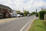
Downton, The Royal Oak geograph.org.uk 1099367

Downton is a hamlet in Hampshire, England, clustered around a crossroads on the A337 road (Lymington to New Milton) with a lane to the sea southwards whilst another lane leads north to Hordle. Most of the population today live in the part that has been re-allocated to the civil parish of Milford-on-Sea (in which statistical urban area the majority of the population at the 2011 Census was included); the area north of the A337 is in Hordle. Part of the Green belt, its population fluctuates as it has two holiday/static home parks with amenities and some small camp sites.

Excerpt from the Wikipedia article Downton, Hampshire (License: CC BY-SA 3.0, Authors, Images).

Downton, Hampshire
Christchurch Road, New Forest Milford-on-Sea

Geographical coordinates (GPS) Address Nearby Places
placeShow on map

Wikipedia: Downton, HampshireContinue reading on Wikipedia

Geographical coordinates (GPS)

Latitude Longitude
N 50.74 ° E -1.62 °
placeShow on map

Address

The Royal Oak

Christchurch Road
SO41 0LA New Forest, Milford-on-Sea
England, United Kingdom
mapOpen on Google Maps

Downton, The Royal Oak geograph.org.uk 1099367
Share experience

Nearby Places

Milford on Sea
Milford on Sea

Milford on Sea, often hyphenated, is a large coastal village and civil parish in the New Forest district, on the Hampshire coast, England. The parish had a population of 4,660 at the 2011 census and is centred about 3 miles (4.8 km) south of Lymington. Tourism and businesses for quite prosperous retirees as well as the care sector make up large parts of its economy. Businesses include restaurants, cafés, tea rooms, small shops, garden centres, pubs and camping/lodge/caravan parks, bed-and-breakfasts and a few luxury hotels. Shops cluster on its small high street, which fronts a village green. The western cliffs are accessed by flights of steps. In common with the flatter coast by the more commercial and eastern part of Milford, they have car parks with some facilities, which, along with many apartment blocks and houses, have close views of The Needles, which are the main, large chalk rocks immediately next to the Isle of Wight. Its western coast is a large bank of shingle below green cliffs. Bathing, when seas are calm, is favourable as tides are relatively muted for the coast at this point and thin sandbanks are nearby at lower water. The eastern part of the place culminates in Hurst Castle, Hurst Point which is a 16th-century defensive fort with later modifications, which has a museum, visitor tour rides and amenities for tourists. Much of the land of the parish has been recognised and protected from dense habitation by a surrounding green belt buffer zone of land, recognising its heath soil associated with the New Forest, its biodiverse wet woodland in the west (a local nature reserve which hosts badgers, fish and many bird species) and various water type marshes including an RSPB reserve in the east.