place

Alicehead

AC with 0 elementsDerbyshire geography stubsNorth East Derbyshire DistrictVillages in Derbyshire
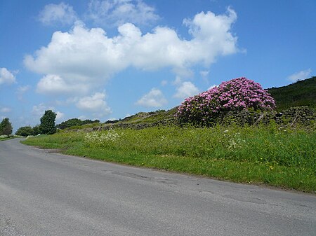
Alicehead Road
Alicehead Road

Alicehead is a small area of settlement in Derbyshire, England, 9 miles (14 km) south-west of Chesterfield. It consists of four farms and a cottage on Alicehead Road, close to the junction of Darley Road and the A632. The area contains 1.9 hectares (4.7 acres) of upland heathland. The population of the settlement was only minimal at the 2011 Census. Details are included in the civil parish of Ashover.

Excerpt from the Wikipedia article Alicehead (License: CC BY-SA 3.0, Authors, Images).

Alicehead
Alice Head Road, North East Derbyshire

Geographical coordinates (GPS) Address Nearby Places
placeShow on map

Wikipedia: AliceheadContinue reading on Wikipedia

Geographical coordinates (GPS)

Latitude Longitude
N 53.19 ° E -1.501 °
placeShow on map

Address

Alice Head Road

Alice Head Road
S45 0DQ North East Derbyshire
England, United Kingdom
mapOpen on Google Maps

Alicehead Road
Alicehead Road
Share experience

Nearby Places

North East Derbyshire

North East Derbyshire is a local government district in Derbyshire, England. It borders the districts of Chesterfield, Bolsover, Amber Valley and Derbyshire Dales in Derbyshire, and Sheffield and Rotherham in South Yorkshire. The population of the district as taken at the 2011 Census was 99,023. The district council is a non-constituent partner member of the Sheffield City Region Combined Authority. In 2011, it formed a joint working arrangement with Bolsover District Council. Under this arrangement the two councils operate shared senior management roles. Other management roles and teams are also shared. The council's head office was originally based outside the district, in the town of Chesterfield, which the district surrounds on three sides, and thus acts as the shopping and work centre for much of the district. However the council relocated to District Council Offices, Mill Lane, Wingerworth, within its own administrative area, in April 2015. Settlements in the district include: Arkwright Town and Ashover Barlow Calow and Clay Cross Dronfield Eckington Grassmoor Holmesfield, Holymoorside and Holmewood Killamarsh Morton North Wingfield Pilsley Renishaw and Ridgeway Shirland, Spinkhill and Stonebroom Tupton WingerworthThe district was formed on 1 April 1974 under the Local Government Act 1972. It was a merger of the Clay Cross and Dronfield urban districts along with all but one parish of Chesterfield Rural District.

Ashover
Ashover

Ashover is a village and civil parish in the English county of Derbyshire. It is in the North East Derbyshire district of the county. The population of the civil parish taken at the 2011 Census was 1,905. It sits in a valley, not far from the town of Matlock and the Peak District national park. The centre of the village is a conservation area. The River Amber flows through the village. Although Ashover is a small settlement, the actual ward boundaries of the village extend for many miles, including the nearby settlements of Alicehead, Alton, Ashover Hay, Farhill, Kelstedge, Littlemoor, Milltown, Spitewinter, Stone Edge and Uppertown. The two major roads, running through the parish, are the A632 from Matlock to Chesterfield, and the A615 from Matlock to Alfreton. The area along that part of the A615 is named Doehole. Slack is a small hamlet, within the parish, which is south west of Kelstedge on the A632; nearby to there, on Robridding Road (off Wirestone Lane), is the Eddlestow Lot Picnic Site, which has been developed in the former Wirestone Quarry: it is surrounded by heathland vegetation. The picnic site provides a good base to explore the local Public Rights of Way. Circular walks are waymarked from the car park, a leaflet is available by contacting the County Council. There is public access into many of the adjacent Forestry Commission owned woodlands. The site has plants including heather and bilberry. The other numbered roads in the parish are the B5057 from near North Brittain to Stone Edge, the B6036 between Kelstedge and Dalebank running past Ashover itself, and the B6014 from near Butterley to just past Ashover Hay. Fallgate is a hamlet beside the River Amber, in the south-east corner of the parish, off the B6036 to Woolley Moor and Handley.

Somersall Hall

Somersall Hall is a small country house near Brampton, Chesterfield, Derbyshire. It is a Grade II listed building.The Clarke family owned the estate in the 16th century. Godfrey Clarke and his son Sir Gilbert Clarke served as High Sheriff of Derbyshire in 1652 and 1676 respectively. Sir Gilbert bought an additional estate at Chilcote Hall in 1672. His son Godfrey Clarke was Member of Parliament for Derbyshire. He left the estate to his nephew, also Godfrey Clarke, who lived at Chilcote, was High Sheriff in 1740, bought Sutton Scarsdale Hall and built a new house at Somersall. The new house was built in 1763 on the site of an earlier 17th-century house and incorporates some of the early features. The new work created a three-storey three-bayed house with an east-facing entrance front. In the 19th century a two-storey wing was added to the north of the frontage. A gazebo (possibly originally part of the house) is Grade II* listed and the gatepiers in front of the house are listed at Grade II.Sutton became the family seat and Somersall was let out as a farmhouse. Godfrey Bagnall Clarke died without issue and his estates passed to his sister and then to her daughter who married Walter Butler, 18th Earl of Ormonde. On the Earls death in 1824 the estates were broken up. The house was rented for about 30 years in the early to middle part of the 20th century to John and Rosemary Milward and their family, John being a Milward's Needles heir and the surgeon at Chesterfield Hospital. They later bought the ancient Barlow Woodseats Hall in Barlow, Derbyshire and restored it.