Vinohrady

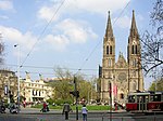
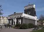
Královské Vinohrady (in English literally "Royal Vineyards" German: Königliche Weinberge) is a cadastral district in Prague. It is so named because the area was once covered in vineyards dating from the 14th century. Vinohrady lies in the municipal and administrative districts of Prague 2 (west part), Prague 3 (north-east part) and Prague 10 (south-east part), little parts also of Prague 1 (Prague State Opera and Federal Assembly of Czechoslovakia) and Prague 4 (near Nusle). Between 1788–1867 it was called Viničné Hory (Vineyard Mountains). From 1867 to 1968 it was called Královské Vinohrady ("Royal Vineyards"). In 1875, Královské Vinohrady was divided into two parts, Královské Vinohrady I and Královské Vinohrady II, the part I was renamed to Žižkov and the part II to Královské Vinohrady in 1877. In 1922 Královské Vinohrady was made part of Prague as district XII. In 1949, the west part was conjoined with Prague 2 and the east part remain separate district Prague 12. In 1960, where Prague division was reduced from 16 to 10 administrative districts, the north part of Prague 12 was conjoined with Žižkov into Prague 3 and the south part was joined to Prague 10. Local patriots say that the real reason was that Královské Vinohrady was known as a "bourgeois" district and thus politically unreliable for the then-ruling Communist Party of Czechoslovakia. The historic part of Prague Main Railway Station (open 1871 as Franz Joseph I Station) is situated at the margin of Vinohrady. City Electric Tramway of Královské Vinohrady (1897) were a base of the Prague net of municipal electric tramway.
Excerpt from the Wikipedia article Vinohrady (License: CC BY-SA 3.0, Authors, Images).Vinohrady
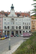
Chodská, Prague Vinohrady
Geographical coordinates (GPS) Address Nearby Places Show on map
Geographical coordinates (GPS)
| Latitude | Longitude |
|---|---|
| N 50.075555555556 ° | E 14.445833333333 ° |
Address
Chodská 1263/26
120 00 Prague, Vinohrady
Prague, Czechia
Open on Google Maps


