Ma Tau Wai

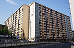
Ma Tau Wai (Chinese: 馬頭圍, originally 碼頭圍, historically 古瑾圍) is an area in the Kowloon City District, Kowloon, Hong Kong. It was originally a walled village (Cantonese: Wai) between present-day Argyle Street and Prince Edward Road West, east of present-day St. Teresa's Hospital.The area of Ma Tau Wai is not as well-defined as the original village, as the geographic features have been lost. The Ma Tau Wai Road in To Kwa Wan does not pass through Ma Tau Wai proper, although it was originally intended to. Ma Tau Wai is sometimes referred to the area south of Argyle Street and north of To Kwa Wan.The public housing estate Ma Tau Wai Estate is named after the area / the original village.
Excerpt from the Wikipedia article Ma Tau Wai (License: CC BY-SA 3.0, Authors, Images).Ma Tau Wai
Ma Tau Kok Road, Kowloon Ma Tau Wai (Kowloon City District)
Geographical coordinates (GPS) Address Nearby Places Show on map
 Continue reading on Wikipedia
 Geographical coordinates (GPS)
| Latitude | Longitude |
|---|---|
| N 22.32351 ° | E 114.18646 ° |
Address
芙蓉樓 Hibiscus House
Ma Tau Kok Road
Kowloon, Ma Tau Wai (Kowloon City District, Ma Tau Wai Estate)
Hong Kong, China
Open on Google Maps