Richmond Hill, Queens

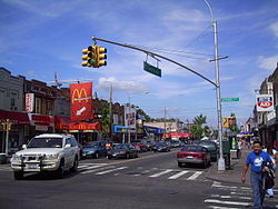
Richmond Hill is a commercial and residential neighborhood located in the southwestern section of the New York City borough of Queens. The area borders Kew Gardens and Forest Park to the north, Jamaica and South Jamaica to the east, South Ozone Park to the south, and Woodhaven and Ozone Park to the west. The neighborhood is split between Queens Community Board 9 and 10.Richmond Hill is known as Little Guyana for its large Indo-Caribbean American (especially Indo-Guyanese and Indo-Trinidadian) population. It’s also called Little Punjab due to its large Punjabi American population. Richmond Hill is home to a density of Sikh, Roman Catholic, Eastern Orthodox, Protestant, Hindu, Jewish, and Muslim places of worship. Main commercial streets in the neighborhood include Jamaica Avenue, Atlantic Avenue and Liberty Avenue. The portion of the neighborhood south of Atlantic Avenue is also known as South Richmond Hill. The Long Island Rail Road provides freight access via the Montauk Branch, which runs diagonally through the neighborhood from northwest to southeast. Many residents own homes, though some also rent within small apartment buildings. Richmond Hill is located in Queens Community District 9 and its ZIP Codes are 11418 and 11419. It is patrolled by the New York City Police Department's 102nd Precinct. Politically, Richmond Hill is represented by the New York City Council's 28th, 30th, and 32nd Districts.
Excerpt from the Wikipedia article Richmond Hill, Queens (License: CC BY-SA 3.0, Authors, Images).Richmond Hill, Queens
117th Street, New York Queens
Geographical coordinates (GPS) Address Nearby Places Show on map
Geographical coordinates (GPS)
| Latitude | Longitude |
|---|---|
| N 40.695 ° | E -73.83 ° |
Address
117th Street 91-17
11418 New York, Queens
New York, United States
Open on Google Maps


