Weston by Welland
Civil parishes in NorthamptonshireNorth NorthamptonshireNorthamptonshire geography stubsUse British English from March 2014Villages in Northamptonshire

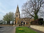
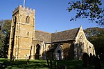
Weston by Welland is a village and civil parish in the north of the English county of Northamptonshire administered as part of North Northamptonshire. As its name suggests, it is near to the River Welland that, thereabouts, forms the boundary with the county of Leicestershire. The Wheel & Compass pub stands on the village's outskirts. At the time of the 2001 census, the parish's population was 141 people, including Sutton Bassett and increasing to 246 at the 2011 Census.The village's name means 'Western farm/settlement by the River Welland'.
Excerpt from the Wikipedia article Weston by Welland (License: CC BY-SA 3.0, Authors, Images).Weston by Welland
The Lane,
Geographical coordinates (GPS) Address Nearby Places Show on map
Geographical coordinates (GPS)
| Latitude | Longitude |
|---|---|
| N 52.5159 ° | E -0.8594 ° |
Address
The Lane
The Lane
LE16 8HU , Weston by Welland
England, United Kingdom
Open on Google Maps


