Thorpe Morieux
Babergh DistrictCivil parishes in SuffolkSuffolk geography stubsVillages in Suffolk

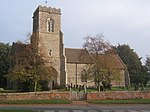
Thorpe Morieux ( Mə-ROO) is a small village and civil parish in Suffolk, England. It is 10 miles south-east of Bury St Edmunds and 10 miles north east of Sudbury. Located in Babergh district, the parish contains the hamlets of Thorpe Green and Almshouses Green, as well as Great Hastings Wood (part of the Thorpe Morieux Woods SSSI), which is classified as Ancient Woodland. It was anciently in the Cosford Hundred. There are 14 listed buildings in the parish, mostly grade II with the grade II* Thorpe Hall and the grade I parish church of St Mary the Virgin.The village is located on the river Brett.
Excerpt from the Wikipedia article Thorpe Morieux (License: CC BY-SA 3.0, Authors, Images).Thorpe Morieux
Bury Road, Babergh
Geographical coordinates (GPS) Address Nearby Places Show on map
Geographical coordinates (GPS)
| Latitude | Longitude |
|---|---|
| N 52.145 ° | E 0.836 ° |
Address
Bury Road
Bury Road
IP30 0NW Babergh
England, United Kingdom
Open on Google Maps


