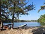
Indian Head River
Hanover, MassachusettsPembroke, MassachusettsRivers of MassachusettsRivers of Plymouth County, Massachusetts

The Indian Head River rises on the southern boundary of Hanover, Massachusetts and northern boundary line of Hanson, Massachusetts at the intersection of tributaries from Drinkwater River in Hanover and Indian Head Brook in Hanson. The river then flows east along the Hanover-Pembroke border. The river, 3.7 miles (6.0 km) long, is a tributary of the North River, which flows into Massachusetts Bay. The Indian Head River was an important fishing and water pathway for the Massachuset Indian village of Mattakeeset which was located around the Pembroke Ponds.
Excerpt from the Wikipedia article Indian Head River (License: CC BY-SA 3.0, Authors, Images).Indian Head River
State Street,
Geographical coordinates (GPS) Address Nearby Places Show on map
Geographical coordinates (GPS)
| Latitude | Longitude |
|---|---|
| N 42.096 ° | E -70.846 ° |
Address
River Path Conservation Area
State Street
02339
Massachusetts, United States
Open on Google Maps


