Wiconisco Canal

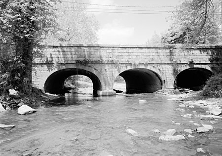
The Wiconisco Canal was a 19th century transportation waterway, about 12 miles (19 km) long, in Dauphin County in the U.S. state of Pennsylvania. Running along the east bank of the Susquehanna River between Millersburg and Duncan's Island at the mouth of the Juniata River, the canal overcame about 42 feet (13 m) of vertical lift through the use of 7 locks.Started by the Commonwealth of Pennsylvania, the canal was completed in 1845 by a private firm and used to ship coal and other goods from northern Dauphin County to distant markets. Sold to a subsidiary of the Pennsylvania Railroad, it continued operating until largely destroyed by a flood in 1889. The canal's biggest aqueduct, No. 3 near Halifax, continues to serve as a highway bridge over Powell Creek. It was added to the National Register of Historic Places in 1988, as the Bridge in Reed Township.
Excerpt from the Wikipedia article Wiconisco Canal (License: CC BY-SA 3.0, Authors, Images).Wiconisco Canal
Newport Road, Penn Township
Geographical coordinates (GPS) Address Nearby Places Show on map
Geographical coordinates (GPS)
| Latitude | Longitude |
|---|---|
| N 40.400833333333 ° | E -77.013611111111 ° |
Address
Riverfront Campground
Newport Road
17020 Penn Township
Pennsylvania, United States
Open on Google Maps


