place

Occupation of the Rhineland

1920s in France1920s in Germany1930 disestablishments in Germany20th century in international relationsAftermath of World War I in France
Aftermath of World War I in GermanyAmerican military occupationsBelgian military occupationsBritish military occupationsDemilitarized zonesForeign relations of the Weimar RepublicFrench military occupationsHistory of the RhinelandMilitary history of GermanyOccupation of the RhinelandUse British English from May 2018
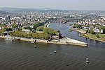
Bundesarchiv Bild 102 08810, Koblenz, Französische Soldaten am Deutsche Eck

The Occupation of the Rhineland from 1 December 1918 until 30 June 1930 was a consequence of the collapse of the Imperial German Army in 1918, after which Germany's provisional government was obliged to agree to the terms of the 1918 armistice. This included accepting that the troops of the victorious powers occupied the left bank of the Rhine and four right bank "bridgeheads" with a 30-kilometre (19 mi) radius around Cologne, Koblenz, Mainz and a 10-kilometre (6 mi) radius around Kehl. Furthermore, the left bank of the Rhine and a 50-kilometre-wide (31 mi) strip east of the Rhine was declared a demilitarized zone. The Treaty of Versailles repeated these provisions, but limited the presence of the foreign troops to fifteen years after the signing of the treaty (until 1934). The purpose of the occupation was on the one hand to give France security against a renewed German attack, and on the other to serve as a guarantee for reparations obligations. After this was apparently achieved with the Young Plan, the occupation of the Rhineland was prematurely ended on 30 June 1930. The administration of occupied Rhineland was under the jurisdiction of the Inter-Allied Rhineland High Commission with its seat at the Upper Presidium of the Rhine Province in Koblenz.

Excerpt from the Wikipedia article Occupation of the Rhineland (License: CC BY-SA 3.0, Authors, Images).

Occupation of the Rhineland
Stresemannstraße, Koblenz Altstadt

Geographical coordinates (GPS) Address Nearby Places
placeShow on map

Wikipedia: Occupation of the RhinelandContinue reading on Wikipedia

Geographical coordinates (GPS)

Latitude Longitude
N 50.357416666667 ° E 7.6019444444444 °
placeShow on map

Address

Struktur- und Genehmigungsdirektion Nord

Stresemannstraße 3-5
56068 Koblenz, Altstadt
Rhineland-Palatinate, Germany
mapOpen on Google Maps

Bundesarchiv Bild 102 08810, Koblenz, Französische Soldaten am Deutsche Eck
Share experience

Nearby Places

Middle Rhine
Middle Rhine

Between Bingen and Bonn, Germany, the river Rhine flows as the Middle Rhine (German: Mittelrhein, pronounced [ˈmɪtl̩ˌʁaɪn] (listen)) through the Rhine Gorge, a formation created by erosion, which happened at about the same rate as an uplift in the region, leaving the river at about its original level, and the surrounding lands raised. This gorge is quite deep, about 130 metres (430 ft) from the top of the rocks down to the average water-line. The "Middle Rhine" is one of four sections (High Rhine, Upper Rhine, Middle Rhine, Lower Rhine) of the river between Lake Constance and the North Sea. The upper half of the Middle Rhine (Rhine Gorge) from Bingen (Rhine-kilometer 526) to Koblenz (Rhine-kilometer 593) is a UNESCO World Heritage Site as a striking cultural landscape with more than 40 castles and fortresses from the Middle Ages, unique terraced vineyards, and many wine-villages. The lower half from Koblenz (Rhine-kilometer 593) to Bonn (Rhine-kilometer 655) is famous for the formerly volcanic Siebengebirge with the Drachenfels volcano. Both parts together are known as "the romantic Rhine". The Middle Rhine Valley has been a major tourist attraction since the 19th century. It is also home to some 450,000 people. The valley owes its special appearance to both its natural shape and human alterations. For two millennia, it has been one of the most important routes for cultural exchange between the Mediterranean region and northern Europe. Situated in the heart of Europe, it was sometimes a border and sometimes a bridge between different cultures. The history of the valley reflects the history of Western Europe. With its many outstanding monuments, its hills full of vines, its settlements crowded on the narrow river banks, and the rows of castles lined up on the hill tops, it is considered the epitome of the Rhine romanticism. It inspired Heinrich Heine to write his famous poem "Lorelei" and Richard Wagner to write his opera Götterdämmerung. The vineyards along the Middle Rhine form the wine-growing region of the same name, see Mittelrhein (wine region).