place

Koblenz

0s BC establishmentsCities in Rhineland-PalatinateDistricts of the Rhine ProvinceKoblenzPopulated places on the Rhine
Source attributionUse American English from December 2021Use mdy dates from December 2021
Koblenz im Buga Jahr 2011 Deutsches Eck 01

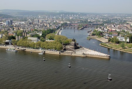
Koblenz (UK: koh-BLENTS, US: KOH-blents, German: [ˈkoːblɛnts] (listen)) is a German city on the banks of the Rhine and the Moselle, a multinational tributary. Koblenz was established as a Roman military post by Drusus around 8 B.C. Its name originates from the Latin (ad) cōnfluentēs, meaning "(at the) confluence". The actual confluence is today known as the "German Corner", a symbol of the unification of Germany that features an equestrian statue of Emperor William I. The city celebrated its 2000th anniversary in 1992. It ranks in population behind Mainz and Ludwigshafen am Rhein to be the third-largest city in Rhineland-Palatinate. Its usual-residents' population is 112,000 (as at 2015). Koblenz lies in a narrow flood plain between high hill ranges, some reaching mountainous height, and is served by an express rail and autobahn network. It is part of the populous Rhineland.

Excerpt from the Wikipedia article Koblenz (License: CC BY-SA 3.0, Authors, Images).

Koblenz
Gymnasialstraße, Koblenz Altstadt

Geographical coordinates (GPS) Address Nearby Places
placeShow on map

Wikipedia: KoblenzContinue reading on Wikipedia

Geographical coordinates (GPS)

Latitude Longitude
N 50.359722222222 ° E 7.5977777777778 °
placeShow on map

Address

Bürgeramt Koblenz

Gymnasialstraße 6
56068 Koblenz, Altstadt
Rhineland-Palatinate, Germany
mapOpen on Google Maps

Koblenz im Buga Jahr 2011 Deutsches Eck 01
Share experience

Nearby Places

Rhine Province
Rhine Province

The Rhine Province (German: Rheinprovinz), also known as Rhenish Prussia (Rheinpreußen) or synonymous with the Rhineland (Rheinland), was the westernmost province of the Kingdom of Prussia and the Free State of Prussia, within the German Reich, from 1822 to 1946. It was created from the provinces of the Lower Rhine and Jülich-Cleves-Berg. Its capital was Koblenz and in 1939 it had 8 million inhabitants. The Province of Hohenzollern was militarily associated with the Oberpräsident of the Rhine Province. The Rhine Province was bounded on the north by the Netherlands, on the east by the Prussian provinces of Westphalia and Hesse-Nassau, and the grand duchy of Hesse-Darmstadt, on the southeast by the Palatinate (a district of the Kingdom of Bavaria), on the south and southwest by Lorraine, and on the west by Luxembourg, Belgium and the Netherlands. The small exclave district of Wetzlar, wedged between the grand duchy states Hesse-Nassau and Hesse-Darmstadt was also part of the Rhine Province. The principality of Birkenfeld, on the other hand, was an enclave of the Grand Duchy of Oldenburg, a separate state of the German Empire. In 1911, the extent of the province was 10,423 km2 (4,024 sq mi); its extreme length, from north to south, was nearly 200 km (120 mi), and its greatest breadth was just under 90 km (56 mi). It included about 200 km (120 mi) of the course of the Rhine, which formed the eastern border of the province from Bingen to Koblenz, and then flows in a north-northwesterly direction inside the province, approximately following its eastern border. It is now part of North Rhine-Westphalia, Rhineland-Palatinate, Saarland, and Hesse.