place

Meadowvale GO Station

1981 establishments in OntarioGO Transit railway stationsGalt SubdivisionRailway stations in Canada opened in 1981Railway stations in Mississauga
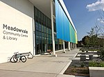
Meadowvale GO Station building

Meadowvale GO Station is a GO Transit railway station on the Milton line in the Greater Toronto Area, Ontario, Canada. It is located at 6845 Millcreek Drive near Derry Road West and Winston Churchill Blvd., in the City of Mississauga in the community of Meadowvale. As with most GO stations, Meadowvale offers parking for commuters, and ticket sales with an attendant during the morning rush hour. In addition to the trains, Meadowvale is served by train-buses outside the rush hours and in the reverse commute direction, by the Milton–Yorkdale–York Mills GO Bus route, by the Highway 407 express buses to Highway 407 Bus Terminal, and by Mississauga Transit buses. Although ridership on the Milton line has grown beyond GO's expectations, the tracks are already busy with Canadian Pacific Railway freight traffic. While it is possible to increase the number of trains, Canadian Pacific Railway will not allow it unless a third GO Transit dedicated right of way track is built. In order to increase capacity, GO Transit has extended the rail platform to accommodate trains with twelve carriages rather than the current ten. As a temporary solution, extensive train-bus services help alleviate congestion.

Excerpt from the Wikipedia article Meadowvale GO Station (License: CC BY-SA 3.0, Authors, Images).

Meadowvale GO Station
Millcreek Drive, Mississauga Meadowvale

Geographical coordinates (GPS) Address Nearby Places
placeShow on map

Wikipedia: Meadowvale GO StationContinue reading on Wikipedia

Geographical coordinates (GPS)

Latitude Longitude
N 43.5975 ° E -79.754444444444 °
placeShow on map

Address

Millcreek Drive
L5N 6C1 Mississauga, Meadowvale
Ontario, Canada
mapOpen on Google Maps

Meadowvale GO Station building
Share experience

Nearby Places

Golden Horseshoe
Golden Horseshoe

The Golden Horseshoe (French: Fer à cheval doré) is a secondary region of Southern Ontario, Canada, which lies at the western end of Lake Ontario, with outer boundaries stretching south to Lake Erie and north to Lake Scugog, Lake Simcoe and Georgian Bay of Lake Huron. The region is the most densely populated and industrialized in Canada. Based on the 2021 census, with a population of 7,759,635 people in its core and 9,765,188 in its greater area, the Golden Horseshoe accounts for over 20 percent of the population of Canada and more than 54 percent of Ontario's population. It is part of the Quebec City–Windsor Corridor, itself part of the Great Lakes megalopolis. The core of the Golden Horseshoe starts from Niagara Falls at the eastern end of the Niagara Peninsula and extends west, wrapping around the western end of Lake Ontario at Hamilton and then turning northeast to Toronto (on the northwestern shore of Lake Ontario), before finally terminating at Clarington in Durham Region. The term Greater Golden Horseshoe is used to describe a broader region that stretches inland from the core to the area of the Trent–Severn Waterway, such as Peterborough, in the northeast, to Barrie and Lake Simcoe in the north, and to the Grand River area, including centres such as Brantford, Waterloo Region, and Guelph to the west. The extended region's area covers approximately 33,500 km2 (13,000 sq mi), out of this, 7,300 km2 (2,800 sq mi) or approximately 22 per cent of the area is covered by the environmentally protected Greenbelt. The Greater Golden Horseshoe forms the neck of the Ontario Peninsula.