Bayford Brook
England river stubsHertfordshire geography stubsLea catchmentRivers of HertfordshireTributaries of the River Lea ... and 1 more
Use British English from June 2015

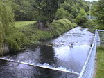
Bayford Brook is a minor tributary of the River Lea. It forms in the hills near Bayford, Hertfordshire and joins the River Lea at Horns Mill Weir. The brook is mostly dry during periods of little rain, as it has a steady gradient with few pools to collect water. The brook is most easily viewed towards its northernmost point where is runs between the two parallel Brickendon Lanes before disappearing into a culvert (illustrated in the photograph). It can also be clearly seen to the left of Brickendon Lane heading away from Hertford at coordinates 51.781884,-0.081008
Excerpt from the Wikipedia article Bayford Brook (License: CC BY-SA 3.0, Authors, Images).Bayford Brook
Lower Hatfield Road, East Hertfordshire Bayford
Geographical coordinates (GPS) Address Nearby Places Show on map
Geographical coordinates (GPS)
| Latitude | Longitude |
|---|---|
| N 51.777777777778 ° | E -0.090277777777778 ° |
Address
Bayfordbury
Lower Hatfield Road
SG13 8RE East Hertfordshire, Bayford
England, United Kingdom
Open on Google Maps


