place

Burrage Pond Wildlife Management Area

Halifax, MassachusettsHanson, MassachusettsMassachusetts geography stubsNatural history of MassachusettsProtected areas of Plymouth County, Massachusetts
Wildlife refuges in Massachusetts
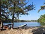
Burrage Pond WMA Scenes

Burrage Pond Wildlife Management Area (or BPWMA) is located in the towns of Hanson and Halifax in Massachusetts, USA. The area is composed of 1,625 acres (6.58 km2) of open land for public use, including hiking, biking, and birding. Hunting is permitted except on Sundays. BPWMA is made up mainly of swampy lands, old cranberry bogs (formally Bog 18, the biggest in the world), and cedar forest. It is managed by the Massachusetts Department of Fisheries and Wildlife.

Excerpt from the Wikipedia article Burrage Pond Wildlife Management Area (License: CC BY-SA 3.0, Authors, Images).

Burrage Pond Wildlife Management Area
Crooker Place,

Geographical coordinates (GPS) Address External links Nearby Places
placeShow on map

Wikipedia: Burrage Pond Wildlife Management AreaContinue reading on Wikipedia

Geographical coordinates (GPS)

Latitude Longitude
N 42.021 ° E -70.876 °
placeShow on map

Address

Burrage Pond Wildlife Management Area

Crooker Place
02341
Massachusetts, United States
mapOpen on Google Maps

linkWikiData (Q5000368)
linkOpenStreetMap (17220241)

Burrage Pond WMA Scenes
Share experience

Nearby Places

Cranberry Specialty Hospital

Cranberry Specialty Hospital was a tuberculosis sanatorium and later a chronic care facility in Hanson, Massachusetts operated by Plymouth County, Massachusetts, which was operational from 1919 until 1992. The hospital was dedicated on May 31, 1919 as Plymouth County Hospital. It was known for its architecture and its modern treatment of tuberculosis-stricken children. The hospital was one of the first to feature a modern, state-of-the-art heating system. An annex was built by 1922 that included additional rooms and wards for patients, as well as an auditorium for patients and employees to enjoy. The hospital was also equipped with a large kitchen, a two-slab morgue, and a laboratory. In 1965, under the direction of superintendent C. Clark Streeter, the hospital transitioned from a tuberculosis sanatorium to a chronic care facility. The hospital complex was renamed the Cranberry Specialty Hospital of Plymouth County in c.1984. During the late 1980s, the hospital struggled with finances, lack of admission, and inadequate treatment. The cost of maintaining the aging historic campus proved too high, and in 1992 the hospital was shut down and relocated to Middleborough, MA, where the new location would shut itself down before 2000.Though most of the campus has remained closed since 1992, the Annex has been used by the Plymouth County Bureau of Criminal Investigation, Plymouth County Beekeepers Association, the University of Massachusetts, 4-H, and is also currently home to the Hanson Food Pantry. The remainder of the property has fallen into a state of disrepair and is condemned. Plans to renovate the large hospital building fell apart after a string of devastating arson fires in the early to mid-2000s that destroyed entire wards, as well as the auditorium, kitchen, and nurses' living area. In 2009 the Town of Hanson erected a perimeter fence around the main building to keep children, vandals, and urban explorers out of the dangerous condemned buildings, which also contain toxic levels of lead."Feasibility of Prospective Reuses of the Former Plymouth County Hospital" (PDF). Archived from the original (PDF) on 2016-12-27. Retrieved 2017-02-03.Following another large fire in 2016, the Town of Hanson appropriated the funds to demolish the large number of abandoned buildings on the grounds. Partial demolition occurred in October 2016 when the far two right wings of the hospital were demolished. Further demolition of the remainder of the hospital building has started as of January 2017. On March 28, 2017, the physical demolition of the historic hospital building began. As of March 29, 2017, all of the remaining buildings have been entirely demolished. The hospital was known for its Mediterranean Revival/Italianate architecture, a rarity in rural Massachusetts.

Monponsett Pond
Monponsett Pond

Monponsett Pond, also called Monponsett Lake and the Twin Lakes, originally one lake is dissected by route 58 into a system of two ponds, West and East, mostly in Halifax, Massachusetts, with a small portion of West Monponsett Pond extending into Hanson. The western basin is 308 acres (1.25 km2), and the eastern basin is 272 acres (1.10 km2). The average depth of both ponds is seven feet and the maximum depth is 13 feet (4.0 m). The outflow is Stump Brook (Snaky River on some historical maps), located in the northwestern part of West Monponsett Pond, which flows in a southwest direction into Robbins Pond, which forms the headwaters of the Sautucket River, a tributary of The Taunton River. The pond is part of the Taunton River Watershed. Water from Monponsett is diverted into Silver Lake, the principal water supply for the City of Brockton. Water diversions from Monponsett into Silver lake are not permitted during the summer months from June 1st - September 30th. Diversions are only allowed during the months of October through May. Route 58 bisects the two ponds. A paved boat launching ramp to West Monponsett Pond is on this highway north of White Island Road. White Island in the center of the pond is known to have been the fishing camp of Wamsutta, brother of Chief Metacomet (also known as King Philip). A culvert connecting the two ponds is nearby. Route 106 runs close to the southern shore of East Monponsett Pond, and Route 36 abuts the southeast corner of East Monponsett Pond, where there is a paved launching ramp. Access to West Monponsett Pond for larger boats can be found off of route 58, and for smaller boats there is an unpaved ramp off Lingan Street. Monponsett Pond Seaplane Base is located on this pond.

Cranland Airport

Cranland Airport, (ICAO: K28M, FAA LID: 28M) in Hanson, Massachusetts is a public use airport owned by Cranland Inc. It has one runway, averages 102 flights per week, and has approximately 28 aircraft based on its field. Benjamin Atwood owned and operated Cranland until his death on July 13, 1967. Atwood died in an airplane crash close to Little Sandy in Pembroke, MA. Atwood also owned Cranberry Sprayers Inc. located at Cranland. Atwood was one of the first jet pilots in the US Air Force. Dennis K. Burke was the sole owner of the airport until July 26, 2011, he sold the airport to Peter T. Oakley, who is also the Airport Manager. Cranland Airport is also the home of Experimental Aircraft Association (EAA) Chapter 279 http://www.eaa279.org/ . The club hosts a fly-In breakfast every third Sunday each month between April and October 8–10am and it is open to the public. Dozens of regional based aircraft from nearby Plymouth, Marshfield, And Mansfield municipal airports fly into Cranland where breakfast is served on airport grounds. Aircraft usually include local Cessnas, piper cubs, and other General Aviation icons. some of the most notable regularly appearing aircraft include a rare radial engine powered variant of the Fairchild F.22, a vintage 1940 Cessna 140, a Vietnam War era Cessna L-19 Bird-Dog observation airplane, a World War II era De Havilland Chipmunk trainer, a Pits S-2 bi-plane, a Boeing PT-17 Stearman bi-plane fitted with a 450 hp engine, and a restored Beechcraft C-45 Expeditor (a former military variant of the Beech 18). The fly-in normally includes flyovers and demonstrations of the present aircraft later, in the June 2012 fly-in an Army National Guard UH-60 Blackhawk helicopter landed at the airport for display being the first time that the Cranland fly-in had any military involvement.