place

Rur

International rivers of EuropePages with Dutch IPAPages with German IPAPages with Limburgish IPARivers of Belgium
Rivers of GermanyRivers of Limburg (Netherlands)Rivers of Liège ProvinceRivers of North Rhine-WestphaliaRivers of the Ardennes (Belgium)Rivers of the EifelRivers of the NetherlandsRoerdalenRoermondRur basinTributaries of the Meuse
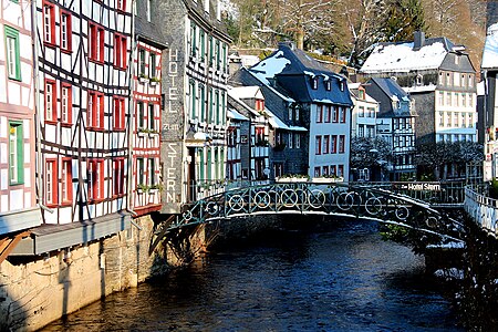
0 Monschau La Rur et la passerelle de l'hôtel zum Stern (1)

The Rur or Roer (German: Rur [ʁuːɐ̯]; Dutch and Limburgish: Roer, Dutch pronunciation: [ˈruːr], Limburgish: [ˈʀuːʀ˦]; French: Rour) is a major river that flows through portions of Belgium, Germany and the Netherlands. It is a right (eastern) tributary to the Meuse (Dutch: Maas). About 90 percent of the river's course is in Germany. It is not to be confused with the rivers Ruhr and Röhr, which are tributaries of the Rhine in North Rhine-Westphalia.

Excerpt from the Wikipedia article Rur (License: CC BY-SA 3.0, Authors, Images).

Rur
Hornerweg, Roermond

Geographical coordinates (GPS) Address Nearby Places
placeShow on map

Wikipedia: RurContinue reading on Wikipedia

Geographical coordinates (GPS)

Latitude Longitude
N 51.197777777778 ° E 5.9811111111111 °
placeShow on map

Address

Louis Raemaekersbrug

Hornerweg
6041 LE Roermond
Limburg, Netherlands
mapOpen on Google Maps

0 Monschau La Rur et la passerelle de l'hôtel zum Stern (1)
Share experience

Nearby Places

Roertunnel
Roertunnel

The Roertunnel is a 2.45 km long land tunnel in Roermond, Netherlands. Opening in 2008, it is one of the longest land tunnels for road traffic in the Netherlands.The tunnel is a part of the A73-south highway, connecting the A73-north in Venlo to the A2 near Echt. The tunnel consists of two main tubes, each containing two traffic lanes without shoulders. One tube contains northbound traffic, while the other contains southbound traffic. Additionally, there is a third tube between the two main tubes that functions as an emergency escape route. The maximum speed inside the tunnels is 100 km/h. Since the highway is directly in the path of urban and protected environmental areas in Roermond, the tunnel has been constructed to lead the traffic underneath East Roermond's urban area, the Roerdal environmental protected zone, and the Roer river. A little north of the Roertunnel, a sister tunnel, The Swalmentunnel, has been constructed according to the same construction principles. That tunnel measures 400m in length and leads underneath the urban area of Swalmen, a village in the municipality of Roermond. Once the tunnel is fully opened, one of the entry ramps in Roermond will have to be redesigned, because according to safety regulations the final entry on the highway must be 300m ahead of the tube of a tunnel, and the entry to the southbound tube in the Roertunnel ends only a few meters ahead of the tunnel. The plan is to redirect all highway traffic to the left lane before entering the tunnel, so that all traffic on the entry ramp can use the right lane for the complete length of the tunnel before merging with the rest of the traffic upon exit of the tunnel.