Battle of the Cedars

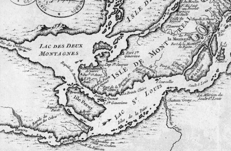
The Battle of the Cedars (French: Bataille des Cèdres) was a series of military confrontations early in the American Revolutionary War during the Continental Army's invasion of Canada that had begun in September 1775. The skirmishes, which involved limited combat, occurred in May 1776 at and around the Cedars, 45 km (28 mi) west of Montreal, British America. Continental Army units were opposed by a small force of British troops leading a larger force of First Nations warriors (primarily Iroquois) and militia. Brigadier General Benedict Arnold, commanding the American military garrison at Montreal, had placed a detachment of his troops at the Cedars in April 1776, after hearing of rumors of British and Indian military preparations to the west of Montreal. The garrison surrendered on May 19 after a confrontation with a combined force of British and Indian troops led by Captain George Forster. American reinforcements on their way to the Cedars were also captured after a brief skirmish on May 20. All of the captives were eventually released after negotiations between Forster and Arnold, who was bringing a sizable force into the area. The terms of the agreement required the Americans to release an equal number of British prisoners, but the deal was repudiated by Congress and no British prisoners were freed. Colonel Timothy Bedel and Lieutenant Isaac Butterfield, leaders of the American force at the Cedars, were court-martialed and cashiered from the Continental Army for their roles in the affair. After distinguishing himself as a volunteer, Bedel was given a new commission in 1777. News of the affair included greatly inflated reports of casualties and often included graphic but false accounts of atrocities committed by the Iroquois, who made up the majority of the British forces.
Excerpt from the Wikipedia article Battle of the Cedars (License: CC BY-SA 3.0, Authors, Images).Battle of the Cedars
Chemin du Fleuve,
Geographical coordinates (GPS) Address Nearby Places Show on map
Geographical coordinates (GPS)
| Latitude | Longitude |
|---|---|
| N 45.3099 ° | E -74.0353 ° |
Address
Chemin du Fleuve 725
J7T 1B7
Quebec, Canada
Open on Google Maps


