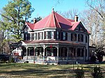
Brandywine, Maryland
Census-designated places in MarylandCensus-designated places in Prince George's County, MarylandWashington metropolitan area

Brandywine is the name of an unincorporated area in Prince George's County, Maryland, United States, that refers both to a census-designated place (CDP) and a zip code area which is much larger (20613), whose areas overlap. The population of Brandywine at the 2020 U.S. Census was 10,550 for the CDP, and the population of ZIP code 20613 was 11,860 in 2010.Brandywine is in the southernmost area of Prince George’s County, surrounded by a rural setting. It is in the Southern Maryland region. Brandywine is also a suburb of two cities: it lies within the outer suburban Washington D.C. area and is also a close suburb of Waldorf.
Excerpt from the Wikipedia article Brandywine, Maryland (License: CC BY-SA 3.0, Authors, Images).Brandywine, Maryland
Bank Street,
Geographical coordinates (GPS) Address Nearby Places Show on map
Geographical coordinates (GPS)
| Latitude | Longitude |
|---|---|
| N 38.698611111111 ° | E -76.849166666667 ° |
Address
Bank Street 9103
20613
Maryland, United States
Open on Google Maps


